1940s Maps of Kings, Illinois
Explore 2 historic maps of Kings from the 1940s. These maps offer a rare glimpse into what life looked like during the 1940s — showing old roads, neighborhoods, homes, and landmarks that have changed or disappeared over time.
Whether you're researching your family's past, planning a metal detecting trip, or studying how Kings's landscape evolved across the 1940s, these high-resolution maps are a powerful tool for exploring the history of this region.
- Focus on a specific era: All maps on this page are from the 1940s, giving you a focused view of this time period.
- See what’s changed: Compare century-old streets, trails, and buildings to today's modern landscape using overlays and satellite layers.
- Research with precision: Use these maps for genealogy, historical research, land use analysis, or educational projects.
- View, download, or print: Maps are fully viewable online in high resolution, and can be downloaded or printed for your own records.
Start exploring Kings's history through authentic maps from the 1940s. This is your window into the past.
Kings, IL maps
(2)- 1946 Map of Kansas, 1977 Print
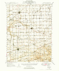 1946 Kansas1977 Print · USGSThe intersection of the New York Central and Chicago and St Louis railroads defines this Illinois prairie landscape shortly after the war. Researchers can trace rural lineages through numerous country schools and cemeteries like College Sch, Shields Cem, and Redmon.
 - 1949 Map of Kansas
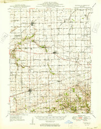 1949 Kansas1949 Print · USGSEastern Illinois at the end of the 1940s reveals a robust landscape of rail-connected towns and country schools. Genealogists can trace family names at Shields Cem or locate community hubs like Embarrass Ch and the settlement of Redmon.2 unique versions available
End of results
Showing maps 1-2 of 2
Top cities near Kings
- Charleston historical maps
- Villa Grove historical maps
- Oakland historical maps
- Newman historical maps
- Kansas historical maps
- Ashmore historical maps
See more
Frequently asked questions
- What are the different types of historical maps available for Kings?
- What is the oldest map of Kings?
- Where can I purchase historical maps of Kings for my home or office?
- Where can I download high-res historical maps of Kings?
- Are there historical topographic maps available for Kings?
- Is there historical aerial imagery available for Kings?
- Where are historical maps of Kings sourced from?