1960s Maps of Oak Park, Illinois
Explore 2 historic maps of Oak Park from the 1960s. These maps offer a rare glimpse into what life looked like during the 1960s — showing old roads, neighborhoods, homes, and landmarks that have changed or disappeared over time.
Whether you're researching your family's past, planning a metal detecting trip, or studying how Oak Park's landscape evolved across the 1960s, these high-resolution maps are a powerful tool for exploring the history of this region.
- Focus on a specific era: All maps on this page are from the 1960s, giving you a focused view of this time period.
- See what’s changed: Compare century-old streets, trails, and buildings to today's modern landscape using overlays and satellite layers.
- Research with precision: Use these maps for genealogy, historical research, land use analysis, or educational projects.
- View, download, or print: Maps are fully viewable online in high resolution, and can be downloaded or printed for your own records.
Start exploring Oak Park's history through authentic maps from the 1960s. This is your window into the past.
Oak Park, IL maps
(2)- 1963 Map of River Forest, 1964 Print
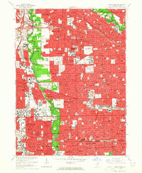 1963 River Forest1964 Print · USGSMid-century suburban expansion meets the Des Plaines riverfront in this 1960s view of western Cook County. Researchers can trace family history through numerous landmarks like St Joseph Cemetery, Maywood Park Racetrack, and the Chicago State Hospital.4 unique versions available
 - 1963 Map of Berwyn, 1965 Print
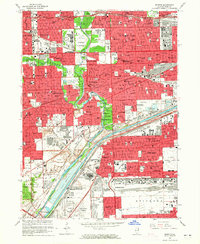 1963 Berwyn1965 Print · USGSThe western Chicago suburbs are seen here in the mid-sixties as post-war industrial and residential growth peaks. Local historians can trace family roots through the dense cemetery district or locate long-standing landmarks like Morton Jr College and the Chicago Zoological Park.3 unique versions available
End of results
Showing maps 1-2 of 2
Top cities near Oak Park
- Chicago historical maps
- Cicero historical maps
- Arlington Heights historical maps
- Evanston historical maps
- Palatine historical maps
- Skokie historical maps
See more
Top neighborhoods of Oak Park
- Samuel A Rothermel Houses historical maps
- Edmund F Burton Row Houses historical maps
- Ridgeland historical maps
Frequently asked questions
- What are the different types of historical maps available for Oak Park?
- What is the oldest map of Oak Park?
- Where can I purchase historical maps of Oak Park for my home or office?
- Where can I download high-res historical maps of Oak Park?
- Are there historical topographic maps available for Oak Park?
- Is there historical aerial imagery available for Oak Park?
- Where are historical maps of Oak Park sourced from?