1960s Maps of Thornton Township, Illinois
Explore 6 historic maps of Thornton Township from the 1960s. These maps offer a rare glimpse into what life looked like during the 1960s — showing old roads, neighborhoods, homes, and landmarks that have changed or disappeared over time.
Whether you're researching your family's past, planning a metal detecting trip, or studying how Thornton Township's landscape evolved across the 1960s, these high-resolution maps are a powerful tool for exploring the history of this region.
- Focus on a specific era: All maps on this page are from the 1960s, giving you a focused view of this time period.
- See what’s changed: Compare century-old streets, trails, and buildings to today's modern landscape using overlays and satellite layers.
- Research with precision: Use these maps for genealogy, historical research, land use analysis, or educational projects.
- View, download, or print: Maps are fully viewable online in high resolution, and can be downloaded or printed for your own records.
Start exploring Thornton Township's history through authentic maps from the 1960s. This is your window into the past.
Thornton Township, IL maps
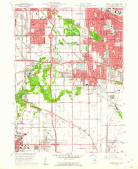
(6)- 1960 Map of Lake Calumet, 1962 Print
 1960 Lake Calumet1962 Print · USGSThe industrial south side of Chicago and the Indiana borderlands meet in this early 1960s survey. Genealogists and historians can trace neighborhood evolution through parish schools like Our Lady of Hungary Sch, early housing at Altgeld Gardens, and the heavy rail lines of the Pennsylvania RR.
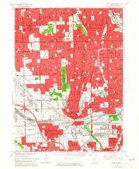
 - 1960 Map of Calumet City, 1962 Print
 1960 Calumet City1962 Print · USGSGreater Chicago's southeastern industrial corridor meets the Indiana state line in this early 1960s survey of burgeoning suburbs and rail hubs. Researchers can trace family roots at Holy Cross Cemetery, locate the old Chicago Hammond Airport, or study the rail network of the Grand Trunk and Monon lines.
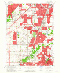
 - 1963 Map of Blue Island, 1965 Print
 1963 Blue Island1965 Print · USGSSouth of Chicago in the early sixties, these burgeoning suburbs grew around a massive network of rail lines and industrial canals. Researchers can trace the footprints of numerous parochial schools, family burial plots in Mt Olivet Cemetery, and landmarks like the Evergreen Plaza Shopping Center.3 unique versions available
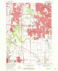
 - 1963 Map of Harvey, 1965 Print
 1963 Harvey1965 Print · USGSSouth Chicago's suburban expansion is in full swing during the early sixties, as residential grids fill the spaces between historic rail lines. Genealogists can locate family sites at St Gabriel Cemetery or Mt Glenwood Cem, while tracing the growth of Harvey, Markham, and Flossmoor.3 unique versions available
 - 1965 Map of Lake Calumet, 1966 Print
 1965 Lake Calumet1966 Print · USGSSoutheast Chicago and the Indiana borderlands were a powerhouse of rail and industry in the mid-sixties. Researchers can trace historic parish life and neighborhood growth through sites like Altgeld Gardens, Hegewisch, and the Chicago Vocational Sch.4 unique versions available
 - 1968 Map of Calumet City, 1970 Print
 1968 Calumet City1970 Print · USGSThe Illinois-Indiana borderlands reached a peak of industrial and suburban development in the late sixties. Researchers can trace the massive rail networks of the Penn Central and find local landmarks like St Margarets Hospital and the Chicago-Hammond Airport.4 unique versions available
End of results
Showing maps 1-6 of 6
Top cities near Thornton Township
- Chicago historical maps
- Cicero historical maps
- Hammond historical maps
- Gary historical maps
- Oak Lawn historical maps
- Berwyn historical maps
See more
Top neighborhoods of Thornton Township
- Calumet City historical maps
- South Holland historical maps
- Dolton historical maps
- Harvey historical maps
- Burnham historical maps
- Dixmoor historical maps
See more
Frequently asked questions
- What are the different types of historical maps available for Thornton Township?
- What is the oldest map of Thornton Township?
- Where can I purchase historical maps of Thornton Township for my home or office?
- Where can I download high-res historical maps of Thornton Township?
- Are there historical topographic maps available for Thornton Township?
- Is there historical aerial imagery available for Thornton Township?
- Where are historical maps of Thornton Township sourced from?