1970s Maps of Deer Creek, Illinois
Explore 2 historic maps of Deer Creek from the 1970s. These maps offer a rare glimpse into what life looked like during the 1970s — showing old roads, neighborhoods, homes, and landmarks that have changed or disappeared over time.
Whether you're researching your family's past, planning a metal detecting trip, or studying how Deer Creek's landscape evolved across the 1970s, these high-resolution maps are a powerful tool for exploring the history of this region.
- Focus on a specific era: All maps on this page are from the 1970s, giving you a focused view of this time period.
- See what’s changed: Compare century-old streets, trails, and buildings to today's modern landscape using overlays and satellite layers.
- Research with precision: Use these maps for genealogy, historical research, land use analysis, or educational projects.
- View, download, or print: Maps are fully viewable online in high resolution, and can be downloaded or printed for your own records.
Start exploring Deer Creek's history through authentic maps from the 1970s. This is your window into the past.
Deer Creek, IL maps
(2)- 1970 Map of Eureka, 1972 Print
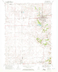 1970 Eureka1972 Print · USGSWoodford and Tazewell counties are shown in the early seventies as established rail and college communities. Trace local family roots through Hartman Cem and Mt Zion Cem or follow the rails of the Toledo Peoria and Western.2 unique versions available
 - 1970 Map of Mackinaw, 1972 Print
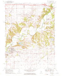 1970 Mackinaw1972 Print · USGSTazewell County's rural heartland is documented here in the early seventies, centered on the Penn Central rail corridor and the winding Mackinaw River. Genealogists and historians can locate the Oak Knoll Sanatorium, old family burials like Stumbaugh Cem, and the small settlement of Lilly.2 unique versions available
End of results
Showing maps 1-2 of 2
Top cities near Deer Creek
- Peoria historical maps
- East Peoria historical maps
- Groveland historical maps
- Morton historical maps
- Washington historical maps
- Eureka historical maps
See more
Frequently asked questions
- What are the different types of historical maps available for Deer Creek?
- What is the oldest map of Deer Creek?
- Where can I purchase historical maps of Deer Creek for my home or office?
- Where can I download high-res historical maps of Deer Creek?
- Are there historical topographic maps available for Deer Creek?
- Is there historical aerial imagery available for Deer Creek?
- Where are historical maps of Deer Creek sourced from?