1900s (20th Century) Maps of Genoa Township, Illinois
Explore 10 historic maps of Genoa Township from the 1900s (20th Century). These maps offer a rare glimpse into what life looked like during the 1900s — showing old roads, neighborhoods, homes, and landmarks that have changed or disappeared over time.
Whether you're researching your family's past, planning a metal detecting trip, or studying how Genoa Township's landscape evolved across the 1900s, these high-resolution maps are a powerful tool for exploring the history of this region.
- Focus on a specific era: All maps on this page are from the 1900s, giving you a focused view of this time period.
- See what’s changed: Compare century-old streets, trails, and buildings to today's modern landscape using overlays and satellite layers.
- Research with precision: Use these maps for genealogy, historical research, land use analysis, or educational projects.
- View, download, or print: Maps are fully viewable online in high resolution, and can be downloaded or printed for your own records.
Start exploring Genoa Township's history through authentic maps from the 1900s. This is your window into the past.
Genoa Township, IL maps
(10)- 1938 Map of Genoa
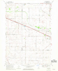
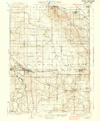 1938 Genoa1938 Print · USGSNorthern Illinois farm country and rail junctions thrive in the late 1930s across the borders of De Kalb and McHenry counties. Genealogists can locate dozens of rural landmarks, from North Kingston Cem and Ney Ch to many local schools like Genoa Center Sch.3 unique versions available
 - 1954 Map of Rockford
 1954 Rockford1954 Print · USGSThe Rock River valley and the Illinois-Wisconsin borderlands are captured here in the mid-1950s during a period of robust industrial and agricultural activity. Genealogists and historians can trace rail-era corridors like the Illinois Central RR and locate landmarks from Big Foot Prairie to Lake Geneva.
 - 1955 Map of Rockford
 1955 Rockford1955 Print · USGSThe Rock River valley and southern Wisconsin dairy country are shown here in the mid-fifties as the region's manufacturing centers grew. Genealogists and historians can trace the paths of the Chicago and North Western RR and Illinois Central RR through hubs like Rockford and Beloit.
 - 1958 Map of Rockford, 1974 Print
 1958 Rockford1974 Print · USGSNorthern Illinois and southern Wisconsin are shown here in the mid-twentieth century as rail-dependent industrial towns began to interface with growing lakefront communities. Genealogists can trace family roots through settlements like Saylesville and Tess Corners or locate historical landmarks like the Rockford Ordnance Depot.4 unique versions available
 - 1963 Map of Rockford
 1963 Rockford1963 Print · USGSThe mid-century industrial corridor along the Rock River is shown here during a period of rapid post-war growth. Researchers can trace the extensive rail lines of the Chicago and North Western or locate local landmarks like the Rockford Ordnance Depot and Holy Hill.
 - 1968 Map of Genoa, 1970 Print
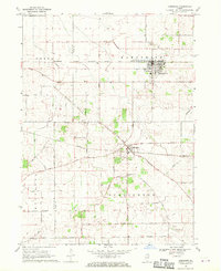
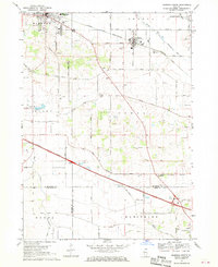
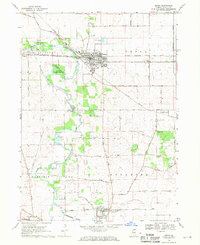 1968 Genoa1970 Print · USGSDeKalb County farmland and growing railroad towns are captured here in the late sixties as the region maintained its agricultural roots. Genealogists can locate family sites near Kingston Cem and Charter Grove or trace the busy Illinois Central rail line.2 unique versions available
 - 1968 Map of Hampshire, 1970 Print
 1968 Hampshire1970 Print · USGSKane and De Kalb counties are captured here in the late sixties as the rural landscape centered on rail-town life. Researchers can trace ancestral farmsteads along Plank Road or locate family plots at Hampshire Center Cem and Burlington Union Cem.2 unique versions available
 - 1968 Map of Marengo South, 1970 Print
 1968 Marengo South1970 Print · USGSIn the late sixties, the rural borderlands of McHenry, DeKalb, and Kane Counties were undergoing change as modern highways intersected old rail lines. Genealogists and local historians can trace family-named roads and sites like Coral Cem, Union Ch, and the Tollgate near Harmony.2 unique versions available
 - 1968 Map of Riley, 1970 Print
 1968 Riley1970 Print · USGSIn the late sixties, this agricultural landscape at the junction of three counties remained centered on family farms and country roads. Researchers can locate specific sites like the No 10 School, Barber Cem, and the Grange Hall near the village of Riley.2 unique versions available
 - 1981 Map of Elgin
 1981 Elgin1981 Print · USGSNorthern Illinois and southern Wisconsin are shown in the early eighties as suburban growth meets glacial terrain. Trace the paths of the Milwaukee Road through Harvard or explore the wetlands of Volo Bog State Natural Area.
End of results
Showing maps 1-10 of 10
Top cities near Genoa Township
- Elgin historical maps
- DeKalb historical maps
- Crystal Lake historical maps
- Lake in the Hills historical maps
- Rutland Township historical maps
- Belvidere historical maps
See more
Top neighborhoods of Genoa Township
Frequently asked questions
- What are the different types of historical maps available for Genoa Township?
- What is the oldest map of Genoa Township?
- Where can I purchase historical maps of Genoa Township for my home or office?
- Where can I download high-res historical maps of Genoa Township?
- Are there historical topographic maps available for Genoa Township?
- Is there historical aerial imagery available for Genoa Township?
- Where are historical maps of Genoa Township sourced from?