1900s (20th Century) Maps of Chesterville, Illinois
Explore 7 historic maps of Chesterville from the 1900s (20th Century). These maps offer a rare glimpse into what life looked like during the 1900s — showing old roads, neighborhoods, homes, and landmarks that have changed or disappeared over time.
Whether you're researching your family's past, planning a metal detecting trip, or studying how Chesterville's landscape evolved across the 1900s, these high-resolution maps are a powerful tool for exploring the history of this region.
- Focus on a specific era: All maps on this page are from the 1900s, giving you a focused view of this time period.
- See what’s changed: Compare century-old streets, trails, and buildings to today's modern landscape using overlays and satellite layers.
- Research with precision: Use these maps for genealogy, historical research, land use analysis, or educational projects.
- View, download, or print: Maps are fully viewable online in high resolution, and can be downloaded or printed for your own records.
Start exploring Chesterville's history through authentic maps from the 1900s. This is your window into the past.
Chesterville, IL maps
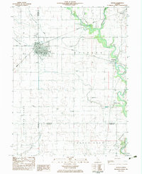
(7)- 1935 Map of Arcola
 1935 Arcola1935 Print · USGSCentral Illinois farming communities thrived along the Illinois Central and Pennsylvania rail lines in the 1930s. Genealogists can trace family roots through numerous rural landmarks like Yoder Cem, Quinn Chapel, and Pulltight Sch.3 unique versions available
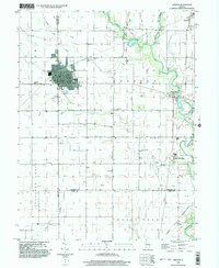
 - 1940 Map of Arcola
 1940 Arcola1940 Print · USGSThe Douglas and Coles County borderlands come alive in this pre-war portrait of central Illinois agricultural life. Researchers can trace dozens of rural school sites such as Pulltight Sch and Little Red Sch, alongside old rail corridors like the Illinois Central.
 - 1958 Map of Decatur, 1971 Print
 1958 Decatur1971 Print · USGSCentral Illinois in the mid-twentieth century shows a landscape defined by industrial rail hubs and the creation of large reservoirs. Researchers can trace historic corridors like the Penn Central or locate landmarks such as Lincoln Log Cabin State Park and Lake Springfield.3 unique versions available
 - 1961 Map of Decatur
 1961 Decatur1961 Print · USGSCentral Illinois in the late fifties was a bustling corridor of rail lines and prairie commerce centered on the state capital. Genealogists and historians can trace the intricate connections between Springfield, Decatur, and dozens of smaller settlements like Nokomis and Arcola.2 unique versions available
 - 1983 Map of Arthur
 1983 Arthur1983 Print · USGSThe Douglas and Moultrie County borderlands come to life in the early 1980s, centered on the rail junction at Arthur. Researchers can trace old rural schoolhouses like Prairie Lane Sch, numerous family burial sites including Yoder Cem, and the specialized Cooks Mills Oil Field.
 - 1985 Map of Decatur
 1985 Decatur1985 Print · USGSCentral Illinois farming and rail hubs thrive in the mid-1980s as Decatur anchors a sprawling network of track and timber. Trace the paths of the Sangamon River and the Illinois Central Gulf RR through old towns like Cerro Gordo and Bement.2 unique versions available
 - 1998 Map of Arthur, 2003 Print
 1998 Arthur2003 Print · USGSArthur and its surrounding prairie landscape are documented here at the close of the twentieth century, showing a unique intersection of faith-based schooling and heavy industry. Genealogists and historians can trace family-named sites like Yoder Cemetery and the German School alongside the active Cooks Mills Oil Field.
End of results
Showing maps 1-7 of 7
Top cities near Chesterville
- Charleston historical maps
- Mattoon historical maps
- Tuscola historical maps
- Sullivan historical maps
- Arcola historical maps
- Villa Grove historical maps
See more
Frequently asked questions
- What are the different types of historical maps available for Chesterville?
- What is the oldest map of Chesterville?
- Where can I purchase historical maps of Chesterville for my home or office?
- Where can I download high-res historical maps of Chesterville?
- Are there historical topographic maps available for Chesterville?
- Is there historical aerial imagery available for Chesterville?
- Where are historical maps of Chesterville sourced from?