1920s Maps of DuPage County, Illinois
Explore 5 historic maps of DuPage County from the 1920s. These maps offer a rare glimpse into what life looked like during the 1920s — showing old roads, neighborhoods, homes, and landmarks that have changed or disappeared over time.
Whether you're researching your family's past, planning a metal detecting trip, or studying how DuPage County's landscape evolved across the 1920s, these high-resolution maps are a powerful tool for exploring the history of this region.
- Focus on a specific era: All maps on this page are from the 1920s, giving you a focused view of this time period.
- See what’s changed: Compare century-old streets, trails, and buildings to today's modern landscape using overlays and satellite layers.
- Research with precision: Use these maps for genealogy, historical research, land use analysis, or educational projects.
- View, download, or print: Maps are fully viewable online in high resolution, and can be downloaded or printed for your own records.
Start exploring DuPage County's history through authentic maps from the 1920s. This is your window into the past.
DuPage County, IL maps
(5)- 1923 Map of Joliet
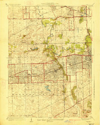
 1923 Joliet1923 Print · USGSJoliet and the Des Plaines River valley are shown here in the 1920s, a hub of heavy industry and vital shipping canals. Genealogists and local historians can trace family roots through numerous country schools like Spaulding School, the Du Page Church, and the expansive State Penitentiary Farm.5 unique versions available
 - 1925 Map of Yorkville
 1925 Yorkville1925 Print · USGSKendall County in the mid-twenties shows a landscape of river-valley commerce and a dense network of interurban electric rail lines. Genealogists can locate family-named schoolhouses like Tamarack School and rural hubs such as Platteville and Helmar.2 unique versions available
 - 1927 Map of Hinsdale
 1927 Hinsdale1927 Print · USGSThe western Chicago suburbs emerged as a hub of transit and leisure in the late twenties, where rail lines met rising commuter towns. Genealogists can trace family names and institutions from St Joseph Institute to the vanished crossroads of Utopia and Lace.3 unique versions available
 - 1928 Map of Elmhurst
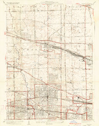 1928 Elmhurst1928 Print · USGSWestern suburbs like Elmhurst and Bensenville appear in the late 1920s as thriving rail hubs before the postwar housing boom. Researchers can trace early family sites at Friedens Cemetery, locate the Lutheran Orphanage, and see the original layout of Elmhurst College.3 unique versions available
 - 1928 Map of Sag Bridge
 1928 Sag Bridge1928 Print · USGSThe Des Plaines valley in the late 1920s reveals a complex network of canals and railways connecting Lemont and Willow Springs. Trace early twentieth-century landmarks like Visitation Boys Camp, Fairmont Cemetery, and the Derby School.4 unique versions available
End of results
Showing maps 1-5 of 5
Top cities of DuPage County
- Wheaton historical maps
- Downers Grove historical maps
- Elmhurst historical maps
- Lombard historical maps
- Carol Stream historical maps
- Glendale Heights historical maps
See more
Frequently asked questions
- What are the different types of historical maps available for DuPage County?
- What is the oldest map of DuPage County?
- Where can I purchase historical maps of DuPage County for my home or office?
- Where can I download high-res historical maps of DuPage County?
- Are there historical topographic maps available for DuPage County?
- Is there historical aerial imagery available for DuPage County?
- Where are historical maps of DuPage County sourced from?