1960s Maps of West Chicago, Illinois
Explore 5 historic maps of West Chicago from the 1960s. These maps offer a rare glimpse into what life looked like during the 1960s — showing old roads, neighborhoods, homes, and landmarks that have changed or disappeared over time.
Whether you're researching your family's past, planning a metal detecting trip, or studying how West Chicago's landscape evolved across the 1960s, these high-resolution maps are a powerful tool for exploring the history of this region.
- Focus on a specific era: All maps on this page are from the 1960s, giving you a focused view of this time period.
- See what’s changed: Compare century-old streets, trails, and buildings to today's modern landscape using overlays and satellite layers.
- Research with precision: Use these maps for genealogy, historical research, land use analysis, or educational projects.
- View, download, or print: Maps are fully viewable online in high resolution, and can be downloaded or printed for your own records.
Start exploring West Chicago's history through authentic maps from the 1960s. This is your window into the past.
West Chicago, IL maps
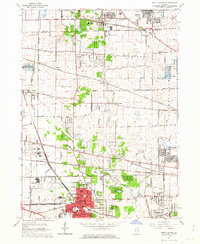
(5)- 1961 Map of Aurora
 1961 Aurora1961 Print · USGSNorthern Illinois at the height of the post-war era reveals a landscape of massive industrial works and thriving river towns. Genealogists and historians can trace the paths of the Lincoln Highway or locate long-standing landmarks like the Green River Ordnance Plant and Starved Rock State Park.
 - 1962 Map of West Chicago, 1963 Print
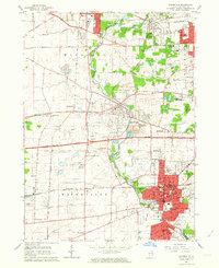
 1962 West Chicago1963 Print · USGSMid-century DuPage County is captured here at a peak of rail activity, with five major lines crossing the prairies and developing towns. Genealogists and local historians can trace family plots at Old Ontarioville Cemetery or locate landmarks like Wheaton College Academy and the Munger rail stop.4 unique versions available
 - 1962 Map of Naperville, 1964 Print
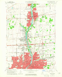
 1962 Naperville1964 Print · USGSMid-century DuPage County shows a landscape transitioning from quiet river towns to bustling suburbs connected by the new East-West Tollway. Genealogists and historians can trace institutional roots at North Central College, the Winfield Sanitarium, and Naperville Cem.4 unique versions available
 - 1964 Map of Aurora North, 1965 Print
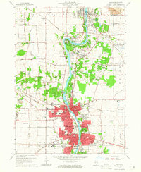
 1964 Aurora North1965 Print · USGSThe Fox River valley in the mid-sixties shows the transition from industrial river towns to expanding suburbs. Researchers can trace the development of civic life through sites like Mooseheart, the Aurora Downs track, and the historic Campana landmark.3 unique versions available
 - 1964 Map of Geneva, 1965 Print
 1964 Geneva1965 Print · USGSThe Fox River valley in the mid-1960s shows a landscape of growing river towns and sprawling forest preserves. Researchers can trace the footprints of institutional landmarks like St Dominic College or find family history at Union Cem and Oak Hill Cem.4 unique versions available
End of results
Showing maps 1-5 of 5
Top cities near West Chicago
- Aurora historical maps
- Naperville historical maps
- Elgin historical maps
- Schaumburg historical maps
- Arlington Heights historical maps
- Bolingbrook historical maps
See more
Frequently asked questions
- What are the different types of historical maps available for West Chicago?
- What is the oldest map of West Chicago?
- Where can I purchase historical maps of West Chicago for my home or office?
- Where can I download high-res historical maps of West Chicago?
- Are there historical topographic maps available for West Chicago?
- Is there historical aerial imagery available for West Chicago?
- Where are historical maps of West Chicago sourced from?