1950s Maps of Effingham County, Illinois
Explore 7 historic maps of Effingham County from the 1950s. These maps offer a rare glimpse into what life looked like during the 1950s — showing old roads, neighborhoods, homes, and landmarks that have changed or disappeared over time.
Whether you're researching your family's past, planning a metal detecting trip, or studying how Effingham County's landscape evolved across the 1950s, these high-resolution maps are a powerful tool for exploring the history of this region.
- Focus on a specific era: All maps on this page are from the 1950s, giving you a focused view of this time period.
- See what’s changed: Compare century-old streets, trails, and buildings to today's modern landscape using overlays and satellite layers.
- Research with precision: Use these maps for genealogy, historical research, land use analysis, or educational projects.
- View, download, or print: Maps are fully viewable online in high resolution, and can be downloaded or printed for your own records.
Start exploring Effingham County's history through authentic maps from the 1950s. This is your window into the past.
Effingham County, IL maps
(7)- 1950 Map of Effingham, 1958 Print
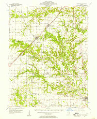
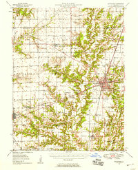 1950 Effingham1958 Print · USGSEffingham and the surrounding townships are shown at a mid-century peak of rail activity and rural development. Genealogists can trace family roots through numerous sites like Wolf Creek Cemetery, St Marys Church, and the settlement at Shumway.4 unique versions available
 - 1951 Map of Effingham
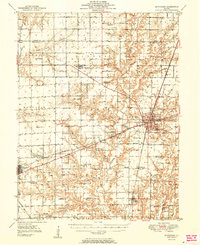 1951 Effingham1951 Print · USGSIn the decade after the war, central Illinois thrived as a rail and agricultural crossroads. Genealogists and historians can locate dozens of country landmarks like Ewington Cem, St Pauls Ch, and the many schools of Summit and Liberty townships.2 unique versions available
 - 1953 Map of Teutopolis, 1955 Print
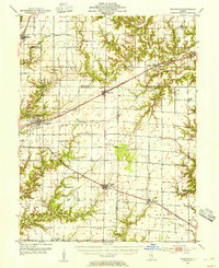 1953 Teutopolis1955 Print · USGSMid-century Effingham County and its neighbors are documented here during a period of agricultural stability and rail-line prominence. Genealogists can locate family landmarks including Elliottstown, Lillyville, and rural schools like Plain Tree Sch.2 unique versions available
 - 1953 Map of Sailor Springs, 1955 Print
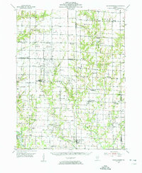 1953 Sailor Springs1955 Print · USGSSoutheast Illinois farmland at the start of the fifties reveals a landscape of tight-knit rural precincts and family homesteads. Genealogists can trace family names through dozens of landmarks like Shouse Chapel, Bethsaida Cem, and the Little Grove Sch.2 unique versions available
 - 1956 Map of Edgewood, 1957 Print
 1956 Edgewood1957 Print · USGSRailroad junctions and rising oil fields define this mid-century look at the Clay and Effingham county lines. Genealogists can trace family names at St Ann Cem, Keen Chapel, and the settlement of La Clede along the ILLINOIS CENTRAL tracks.2 unique versions available
 - 1958 Map of Decatur, 1971 Print
 1958 Decatur1971 Print · USGSCentral Illinois in the mid-twentieth century shows a landscape defined by industrial rail hubs and the creation of large reservoirs. Researchers can trace historic corridors like the Penn Central or locate landmarks such as Lincoln Log Cabin State Park and Lake Springfield.3 unique versions available
 - 1958 Map of Belleville, 1973 Print
 1958 Belleville1973 Print · USGSSouthern Illinois during the mid-twentieth century reveals a landscape of industrial growth and massive new reservoirs. Genealogists and historians can trace the paths of the Illinois Central RR through towns like Centralia or locate landmarks such as Emerald Mound and the Looking Glass Prairie.3 unique versions available
End of results
Showing maps 1-7 of 7
Top cities of Effingham County
- Effingham historical maps
- Altamont historical maps
- Teutopolis historical maps
- Dieterich historical maps
- Watson historical maps
- Edgewood historical maps
See more
Frequently asked questions
- What are the different types of historical maps available for Effingham County?
- What is the oldest map of Effingham County?
- Where can I purchase historical maps of Effingham County for my home or office?
- Where can I download high-res historical maps of Effingham County?
- Are there historical topographic maps available for Effingham County?
- Is there historical aerial imagery available for Effingham County?
- Where are historical maps of Effingham County sourced from?