1940s Maps of Kempton, Illinois
Explore 2 historic maps of Kempton from the 1940s. These maps offer a rare glimpse into what life looked like during the 1940s — showing old roads, neighborhoods, homes, and landmarks that have changed or disappeared over time.
Whether you're researching your family's past, planning a metal detecting trip, or studying how Kempton's landscape evolved across the 1940s, these high-resolution maps are a powerful tool for exploring the history of this region.
- Focus on a specific era: All maps on this page are from the 1940s, giving you a focused view of this time period.
- See what’s changed: Compare century-old streets, trails, and buildings to today's modern landscape using overlays and satellite layers.
- Research with precision: Use these maps for genealogy, historical research, land use analysis, or educational projects.
- View, download, or print: Maps are fully viewable online in high resolution, and can be downloaded or printed for your own records.
Start exploring Kempton's history through authentic maps from the 1940s. This is your window into the past.
Kempton, IL maps
(2)- 1944 Map of Piper City
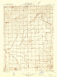 1944 Piper City1944 Print · USGSEast-central Illinois was a landscape of thriving rural school districts and critical rail junctions during the 1940s. Genealogists can locate dozens of family-named landmarks and schools such as Graham Sch and Taylor Sch alongside the Illinois Central tracks.2 unique versions available
 - 1947 Map of Piper City
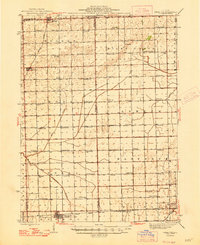 1947 Piper City1947 Print · USGSFord County and the surrounding prairie are captured here in the mid-1940s, showing a landscape defined by rail transport and township schools. Genealogists can locate family landmarks like Milks Grove Ch, the Town Hall, and dozens of named country schools.
End of results
Showing maps 1-2 of 2
Top cities near Kempton
- Dwight historical maps
- Gilman historical maps
- Herscher historical maps
- Onarga historical maps
- Chatsworth historical maps
- Forrest historical maps
See more
Frequently asked questions
- What are the different types of historical maps available for Kempton?
- What is the oldest map of Kempton?
- Where can I purchase historical maps of Kempton for my home or office?
- Where can I download high-res historical maps of Kempton?
- Are there historical topographic maps available for Kempton?
- Is there historical aerial imagery available for Kempton?
- Where are historical maps of Kempton sourced from?