1980s Maps of Paxton, Illinois
Explore 3 historic maps of Paxton from the 1980s. These maps offer a rare glimpse into what life looked like during the 1980s — showing old roads, neighborhoods, homes, and landmarks that have changed or disappeared over time.
Whether you're researching your family's past, planning a metal detecting trip, or studying how Paxton's landscape evolved across the 1980s, these high-resolution maps are a powerful tool for exploring the history of this region.
- Focus on a specific era: All maps on this page are from the 1980s, giving you a focused view of this time period.
- See what’s changed: Compare century-old streets, trails, and buildings to today's modern landscape using overlays and satellite layers.
- Research with precision: Use these maps for genealogy, historical research, land use analysis, or educational projects.
- View, download, or print: Maps are fully viewable online in high resolution, and can be downloaded or printed for your own records.
Start exploring Paxton's history through authentic maps from the 1980s. This is your window into the past.
Paxton, IL maps
(3)- 1984 Map of Paxton, 1985 Print
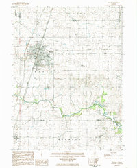 1984 Paxton1985 Print · USGSIn the mid-1980s, the Illinois prairie around Paxton remained a critical rail junction and agricultural center. Family historians can locate several rural burial grounds including Trickle Grove Cem and Webber Cem, or trace the course of the Middle Fork Vermilion River.
 - 1984 Map of Perdueville, 1985 Print
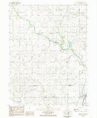 1984 Perdueville1985 Print · USGSThe rural border of Ford and Champaign Counties comes into focus in the mid-1980s, showcasing an era of active rail transit and prairie drainage. Genealogists can locate family landmarks like Meharry Cem and Foster Cemetery near the tracks of the Norfolk and Western railroad.
 - 1985 Map of Champaign, 1986 Print
 1985 Champaign1986 Print · USGSThe Illinois prairie comes alive in this mid-eighties survey of the vital rail corridor between Bloomington and Champaign. Genealogists and historians can trace the development of township hubs like Saybrook and Bellflower or locate Chanute Air Force Base and the Sangamon River.2 unique versions available
End of results
Showing maps 1-3 of 3
Top cities near Paxton
- Rantoul historical maps
- Thomasboro historical maps
- Gifford historical maps
- Cissna Park historical maps
- Rankin historical maps
- Buckley historical maps
See more
Frequently asked questions
- What are the different types of historical maps available for Paxton?
- What is the oldest map of Paxton?
- Where can I purchase historical maps of Paxton for my home or office?
- Where can I download high-res historical maps of Paxton?
- Are there historical topographic maps available for Paxton?
- Is there historical aerial imagery available for Paxton?
- Where are historical maps of Paxton sourced from?