1990s Maps of West City, Illinois
Explore 1 historic maps of West City from the 1990s. These maps offer a rare glimpse into what life looked like during the 1990s — showing old roads, neighborhoods, homes, and landmarks that have changed or disappeared over time.
Whether you're researching your family's past, planning a metal detecting trip, or studying how West City's landscape evolved across the 1990s, these high-resolution maps are a powerful tool for exploring the history of this region.
- Focus on a specific era: All maps on this page are from the 1990s, giving you a focused view of this time period.
- See what’s changed: Compare century-old streets, trails, and buildings to today's modern landscape using overlays and satellite layers.
- Research with precision: Use these maps for genealogy, historical research, land use analysis, or educational projects.
- View, download, or print: Maps are fully viewable online in high resolution, and can be downloaded or printed for your own records.
Start exploring West City's history through authentic maps from the 1990s. This is your window into the past.
West City, IL maps
(1)- 1998 Map of Rend Lake Dam, 2000 Print
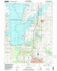 1998 Rend Lake Dam2000 Print · USGSFranklin County in the late nineties centers on the significant reservoir and park system surrounding the Big Muddy River. Genealogists and researchers can trace local roots at Old Ben No 24 Mine, Flatts Sch, and the Hazel Dell Ch.
End of results
Showing maps 1-1 of 1
Top cities near West City
- Herrin historical maps
- West Frankfort historical maps
- Benton historical maps
- Carterville historical maps
- Johnston City historical maps
- Spring Garden historical maps
See more
Frequently asked questions
- What are the different types of historical maps available for West City?
- What is the oldest map of West City?
- Where can I purchase historical maps of West City for my home or office?
- Where can I download high-res historical maps of West City?
- Are there historical topographic maps available for West City?
- Is there historical aerial imagery available for West City?
- Where are historical maps of West City sourced from?