1940s Maps of Poverty Ridge, Illinois
Explore 2 historic maps of Poverty Ridge from the 1940s. These maps offer a rare glimpse into what life looked like during the 1940s — showing old roads, neighborhoods, homes, and landmarks that have changed or disappeared over time.
Whether you're researching your family's past, planning a metal detecting trip, or studying how Poverty Ridge's landscape evolved across the 1940s, these high-resolution maps are a powerful tool for exploring the history of this region.
- Focus on a specific era: All maps on this page are from the 1940s, giving you a focused view of this time period.
- See what’s changed: Compare century-old streets, trails, and buildings to today's modern landscape using overlays and satellite layers.
- Research with precision: Use these maps for genealogy, historical research, land use analysis, or educational projects.
- View, download, or print: Maps are fully viewable online in high resolution, and can be downloaded or printed for your own records.
Start exploring Poverty Ridge's history through authentic maps from the 1940s. This is your window into the past.
Poverty Ridge, IL maps
(2)- 1948 Map of Smithfield
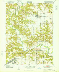 1948 Smithfield1948 Print · USGSFulton County during the late 1940s shows the significant footprint of the Camp Ellis Military Reservation alongside traditional prairie rail towns. Researchers can trace rural life through numerous country schoolhouses like the Little Brick School and Reese Sch, or locate the historic Bernadotte Bridge over the Spoon River.2 unique versions available
 - 1949 Map of Vermont
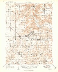 1949 Vermont1949 Print · USGSFulton County and the surrounding tri-county area appear here shortly after the war, centered on the massive Camp Ellis Military Reservation. Researchers can trace the vanished barracks and rail spurs of the camp alongside rural landmarks like the Little Brick School and Bernadotte Bridge.2 unique versions available
End of results
Showing maps 1-2 of 2
Top cities near Poverty Ridge
- Bushnell historical maps
- Lewistown historical maps
- Cuba historical maps
- Avon historical maps
- Vermont historical maps
- Ipava historical maps
See more
Frequently asked questions
- What are the different types of historical maps available for Poverty Ridge?
- What is the oldest map of Poverty Ridge?
- Where can I purchase historical maps of Poverty Ridge for my home or office?
- Where can I download high-res historical maps of Poverty Ridge?
- Are there historical topographic maps available for Poverty Ridge?
- Is there historical aerial imagery available for Poverty Ridge?
- Where are historical maps of Poverty Ridge sourced from?