1970s Maps of Grayville, Illinois
Explore 2 historic maps of Grayville from the 1970s. These maps offer a rare glimpse into what life looked like during the 1970s — showing old roads, neighborhoods, homes, and landmarks that have changed or disappeared over time.
Whether you're researching your family's past, planning a metal detecting trip, or studying how Grayville's landscape evolved across the 1970s, these high-resolution maps are a powerful tool for exploring the history of this region.
- Focus on a specific era: All maps on this page are from the 1970s, giving you a focused view of this time period.
- See what’s changed: Compare century-old streets, trails, and buildings to today's modern landscape using overlays and satellite layers.
- Research with precision: Use these maps for genealogy, historical research, land use analysis, or educational projects.
- View, download, or print: Maps are fully viewable online in high resolution, and can be downloaded or printed for your own records.
Start exploring Grayville's history through authentic maps from the 1970s. This is your window into the past.
Grayville, IL maps
(2)- 1971 Map of Albion South, 1973 Print
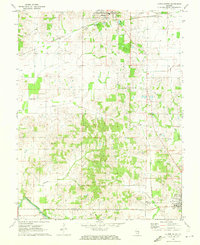 1971 Albion South1973 Print · USGSEdwards County in the early seventies shows a landscape where historic river crossings meet a growing energy sector. Genealogists and historians can trace numerous rural burial grounds like Birk Prairie Cem and old river landmarks such as Dixon Shoals near the Little Wabash River.2 unique versions available
 - 1974 Map of Crossville, 1977 Print
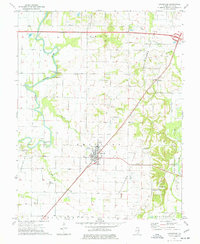 1974 Crossville1977 Print · USGSWhite County’s oil and river economy is on full display in the 1970s as the Albion Oil Field surrounds the hub of Crossville. Genealogists and historians can trace local landmarks like Stokes Chapel, the Riverside Cemetery, and the Penn Central rail line.
End of results
Showing maps 1-2 of 2
Top cities near Grayville
- Mount Carmel historical maps
- Carmi historical maps
- Albion historical maps
- Poseyville historical maps
- New Harmony historical maps
- Crossville historical maps
See more
Frequently asked questions
- What are the different types of historical maps available for Grayville?
- What is the oldest map of Grayville?
- Where can I purchase historical maps of Grayville for my home or office?
- Where can I download high-res historical maps of Grayville?
- Are there historical topographic maps available for Grayville?
- Is there historical aerial imagery available for Grayville?
- Where are historical maps of Grayville sourced from?