1970s Maps of Dahlgren, Illinois
Explore 1 historic maps of Dahlgren from the 1970s. These maps offer a rare glimpse into what life looked like during the 1970s — showing old roads, neighborhoods, homes, and landmarks that have changed or disappeared over time.
Whether you're researching your family's past, planning a metal detecting trip, or studying how Dahlgren's landscape evolved across the 1970s, these high-resolution maps are a powerful tool for exploring the history of this region.
- Focus on a specific era: All maps on this page are from the 1970s, giving you a focused view of this time period.
- See what’s changed: Compare century-old streets, trails, and buildings to today's modern landscape using overlays and satellite layers.
- Research with precision: Use these maps for genealogy, historical research, land use analysis, or educational projects.
- View, download, or print: Maps are fully viewable online in high resolution, and can be downloaded or printed for your own records.
Start exploring Dahlgren's history through authentic maps from the 1970s. This is your window into the past.
Dahlgren, IL maps
(1)- 1974 Map of Dahlgren, 1977 Print
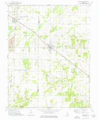 1974 Dahlgren1977 Print · USGSSouthern Illinois prairie life in the mid-1970s is centered on the rail junctions of Dahlgren and Belle Rive. Genealogists can trace family names through dozens of rural sites, including St Johns Cem, Sugar Camp Ch, and Little Egypt Youth Camp.
End of results
Showing maps 1-1 of 1
Top cities near Dahlgren
- Mount Vernon historical maps
- Benton historical maps
- Spring Garden historical maps
- McLeansboro historical maps
- Ina historical maps
- Wayne City historical maps
See more
Frequently asked questions
- What are the different types of historical maps available for Dahlgren?
- What is the oldest map of Dahlgren?
- Where can I purchase historical maps of Dahlgren for my home or office?
- Where can I download high-res historical maps of Dahlgren?
- Are there historical topographic maps available for Dahlgren?
- Is there historical aerial imagery available for Dahlgren?
- Where are historical maps of Dahlgren sourced from?