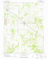
1974 Map of Dahlgren
USGS Topo · Published 1977About this map
The Louisville and Nashville railroad cuts a sharp diagonal across the prairie landscape, connecting the village of Dahlgren to the surrounding Southern Illinois countryside. This mid-1970s survey reveals a region defined by its small agricultural settlements and a dense network of country cemeteries, such as St Johns Cem, Bethel Cem, and the IOOF Cem. The intersection of the Illinois Central Gulf rail line at Belle Rive marks a secondary hub in the northwest, while the southern reaches transition into the rural community of Lovilla. Local religious life is anchored by landmarks like Sugar Camp Ch and Richardson Hill Ch. Physical features such as Lowry Hill and various creek systems, including Auxier Creek and Shelton Creek, break up the township grids, documenting a moment when the rural rail-and-road economy remained firmly in place before modern consolidation.
Find a feature on this map
39 named features on this map. Tap any name to fly to it.
Don’t see what you’re looking for? This feature index may not catch every label — zoom into the map to look around manually.
Map Details
Editions of this 1974 Dahlgren Map
This is the sole edition of this map. No revisions or reprints were ever made.
Other maps of this area

1933 · Mount Vernon
USGS Topo · 1:48,000

1939 · Ina
USGS Topo · 1:62,500

1940 · Mount Vernon
USGS Topo · 1:62,500

1942 · McLeansboro
USGS Topo · 1:62,500

1943 · Ina
USGS Topo · 1:62,500

1945 · McLeansboro
USGS Topo · 1:62,500

1947 · Wayne City
USGS Topo · 1:62,500

1958 · Belleville
USGS Topo · 1:250,000

1962 · Belleville
USGS Topo · 1:250,000

1964 · Opdyke
USGS Topo · 1:24,000