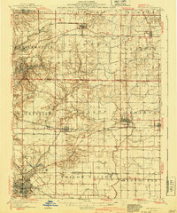
1962 Map of Belleville
USGS Topo · Published 1962About this map
Belleville serves as the western anchor for this regional study, which captures Southern Illinois during a period of significant infrastructure development. The massive Carlyle Reservoir dominates the landscape along the Kaskaskia River, while Scott A F B appears as a prominent military installation near O'Fallon. This 1950s data highlights a dense network of major transport corridors, including the Baltimore and Ohio and Illinois Central railroads, which facilitated the region's agricultural and industrial output.
Find a feature on this map
78 named features on this map. Tap any name to fly to it.
Don’t see what you’re looking for? This feature index may not catch every label — zoom into the map to look around manually.
Map Details
Editions of this 1962 Belleville Map
This is the sole edition of this map. No revisions or reprints were ever made.
Historical Maps of Belleville Through Time
3 maps found