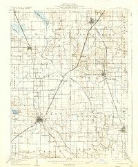
1906 Map of Eldorado
USGS Topo · Published 1906About this map
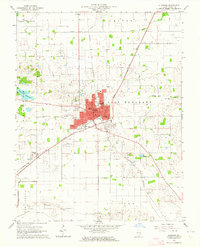
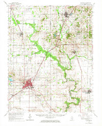
The Eldorado rail junction serves as the primary hub of this turn-of-the-century landscape, where the Illinois Central RR intersects with the Louisville and Nashville and other regional lines. The survey captures a complex network of early 20th-century Southern Illinois transit, featuring the Middlepoint Roland Sta and smaller trackside stops like Gossett and Texas City. Beyond the iron rails, the land is defined by the winding course of the North Fork Saline River, which carves through townships like Eldorado, Omaha, and Equality. Local industry and rural infrastructure are evident through landmarks like Francis Mills and the established settlements of Norris City and Ridgway. The map's detailed boundaries between Hamilton, White, Saline, and Gallatin counties reflect the administrative divisions of the era, while named prairie and grove regions suggest the original vegetation patterns being converted into a grid of homesteads and small farm communities.
Find a feature on this map
51 named features on this map. Tap any name to fly to it.
Don’t see what you’re looking for? This feature index may not catch every label — zoom into the map to look around manually.
Map Details
Editions of this 1906 Eldorado Map
2 editions found
Historical Maps of Eldorado Through Time
9 maps found