
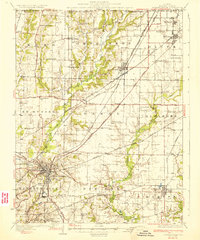
1906 Map of Breese
USGS Topo · Published 1958About this map
Settlement in eastern Madison and western Clinton counties at the turn of the century is defined by tight clusters of German-heritage towns and a dense network of rural schools. Breese and Trenton serve as the primary rail hubs, while smaller centers like Aviston, New Baden, and Germantown anchor the agricultural landscape. The region's transport is dictated by the Baltimore and Ohio Southwestern RR and the Southern RR, which cut across the prairie toward St. Louis.
Find a feature on this map
62 named features on this map. Tap any name to fly to it.
Don’t see what you’re looking for? This feature index may not catch every label — zoom into the map to look around manually.
Map Details
Editions of this 1906 Breese Map
This is the sole edition of this map. No revisions or reprints were ever made.
Other maps of this area

1907 · Breese
USGS Topo · 1:62,500

1907 · Belleville
USGS Topo · 1:62,500

1910 · Carlyle
USGS Topo · 1:62,500

1910 · Okawville
USGS Topo · 1:62,500

1912 · New Athens
USGS Topo · 1:62,500

1927 · Edwardsville
USGS Topo · 1:62,500

1931 · Hoyleton
USGS Topo · 1:48,000
1932 · Edwardsville
USGS Topo · 1:62,500
1932 · Greenville
USGS Topo · 1:62,500
1932 · Nashville
USGS Topo · 1:62,500