
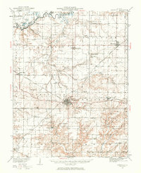
1932 Map of Nashville
USGS Topo · Published 1960About this map
Nashville serves as the central hub of this Southern Illinois landscape during the early 1930s, situated at the junction of the Louisville and Nashville and Missouri Illinois railroads. The survey reveals a rural society structured around local education and faith, evidenced by the high density of country schools like Sassafras Sch, Hogshead Sch, and Nuptial Sch, alongside centers of worship such as North Prairie Ch. To the north, the Kaskaskia River and Crooked Creek define the boundary between Clinton and Washington Counties, where bottomland features like Horseshoe Lake and Big Forked Lake punctuate the floodplain. The rectangular survey system is clearly visible, anchored by the Third Principal Base Line, which organizes the townships of Covington, Hoyleton, and Bolo. Settlement patterns follow the rail lines, connecting towns like Addieville and Beaucoup to the wider region via State Highway No 15.
Find a feature on this map
76 named features on this map. Tap any name to fly to it.
Don’t see what you’re looking for? This feature index may not catch every label — zoom into the map to look around manually.
Map Details
Editions of this 1932 Nashville Map
2 editions found
Other maps of this area

1906 · Breese
USGS Topo · 1:62,500

1907 · Breese
USGS Topo · 1:62,500

1910 · Carlyle
USGS Topo · 1:62,500

1910 · Okawville
USGS Topo · 1:62,500

1914 · Centralia
USGS Topo · 1:62,500

1914 · Coulterville
USGS Topo · 1:62,500

1917 · Coulterville
USGS Topo · 1:62,500

1924 · Pinckneyville
USGS Topo · 1:62,500

1926 · Pinckneyville
USGS Topo · 1:62,500

1926 · Duquoin
USGS Topo · 1:62,500