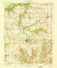
1936 Map of Nashville
USGS Topo · Published 1969About this map
Nashville serves as the hub of this Washington County landscape, where the Illinois Missouri Railroad and Illinois Central Railroad intersect in a classic Midwestern transit pattern. The northern reaches are defined by the winding Kaskaskia River and a cluster of water bodies including Big Flat Lake and Turkey Lake. This survey reveals an exceptionally dense network of early 20th-century rural education, with dozens of family-named institutions like Grottendick Sch, McKelvey Sch, and Hogshead Sch serving isolated farming communities.
Find a feature on this map
70 named features on this map. Tap any name to fly to it.
Don’t see what you’re looking for? This feature index may not catch every label — zoom into the map to look around manually.
Map Details
Editions of this 1936 Nashville Map
2 editions found

Other maps of this area

1906 · Breese
USGS Topo · 1:62,500

1907 · Breese
USGS Topo · 1:62,500

1910 · Carlyle
USGS Topo · 1:62,500

1910 · Okawville
USGS Topo · 1:62,500

1914 · Centralia
USGS Topo · 1:62,500

1914 · Coulterville
USGS Topo · 1:62,500

1917 · Coulterville
USGS Topo · 1:62,500

1924 · Pinckneyville
USGS Topo · 1:62,500

1926 · Pinckneyville
USGS Topo · 1:62,500

1926 · Duquoin
USGS Topo · 1:62,500