
Loading...
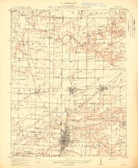
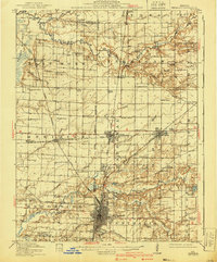
Loading map...1914 Map of Centralia
USGS Topo · Published 1914About this map
Centralia stands as a significant railroad hub in the early twentieth century, where the tracks of the Illinois Central RR, Southern RR, and Chicago Burlington and Quincy converge. This survey captures a landscape defined by its grid of rural schools, such as the curiously named Possumtrot School, Red Stripe School, and Watson Springs School, illustrating the density of small communities like Sandoval and Odin before modern consolidation.
Find a feature on this map
91 named features on this map. Tap any name to fly to it.
Don’t see what you’re looking for? This feature index may not catch every label — zoom into the map to look around manually.
Map Details
Date Portrayed1914
Date Published1914
PublisherU.S. Geological Survey
Map TypeTopographic
Scale1:62,500
Physical Dimensions16.4 x 19.7 inches
Editions of this 1914 Centralia Map
3 editions found
Historical Maps of Centralia Through Time

Featured Locations
Source Details
SourceU.S. Geological Survey
CopyrightPublic Domain