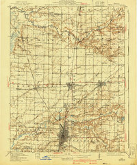
1914 Map of Centralia
USGS Topo · Published 1940About this map
The railroad hubs of Centralia, Odin, and Sandoval anchor this mid-1930s landscape, illustrating a period when the intersection of major rail lines like the Baltimore and Ohio and the Illinois Central drove the local economy. The terrain transitions from the low-lying Boulder Bottoms along the Kaskaskia River to the rolling uplands of Fikes Hill. This survey captures a dense network of country schools, such as the uniquely named Toad Island School and Possomtrot School, which served the rural communities between the burgeoning town centers of Central City and Wamac.
Find a feature on this map
97 named features on this map. Tap any name to fly to it.
Don’t see what you’re looking for? This feature index may not catch every label — zoom into the map to look around manually.
Map Details
Editions of this 1914 Centralia Map
3 editions found
Other maps of this area

1910 · Carlyle
USGS Topo · 1:62,500

1914 · Centralia
USGS Topo · 1:62,500

1931 · Hoyleton
USGS Topo · 1:48,000

1932 · Greenville
USGS Topo · 1:62,500

1932 · Nashville
USGS Topo · 1:62,500

1933 · Mount Vernon
USGS Topo · 1:48,000

1934 · Salem
USGS Topo · 1:62,500

1935 · Centralia
USGS Topo · 1:62,500

1936 · Nashville
USGS Topo · 1:62,500

1938 · Salem
USGS Topo · 1:62,500