1914 Map of Centralia
USGS Topo · Published 1914About this map
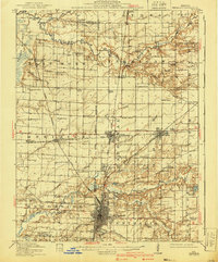
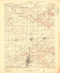
Centralia serves as a major rail hub in this early 20th-century landscape, where the Illinois Central RR, Southern RR, and Chicago and Burlington lines converge. The town's grid is meticulously detailed, extending northward through Central City to Junction City. This industrial density contrasts with the surrounding agricultural townships like Sandoval and Odin, where the land is dotted with a remarkably high concentration of rural schoolhouses. Distinctive names like Possomtrot School, Toad Island School, and Red Stripe School highlight the localized character of these early educational districts.
Find a feature on this map
92 named features on this map. Tap any name to fly to it.
Don’t see what you’re looking for? This feature index may not catch every label — zoom into the map to look around manually.
Map Details
Editions of this 1914 Centralia Map
3 editions found