
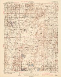
1943 Map of Ina
USGS Topo · Published 1943About this map
Benton and its neighboring coal and rail communities anchoring the southern edge of Jefferson and Franklin Counties represent a significant crossroads of mid-century Illinois industry. The landscape is defined by the Big Muddy River and Casey Fork, which carve through a network of small settlements like Ina, Whittington, and Nason. A dense concentration of rural education and faith is evident, with several dozen small country schools such as Hungry Hill Sch and Mulberry Sch scattered alongside community anchors like Williams Chapel and Antioch Ch. Notably, the area around Ina features local institutions including King College and Conner College, suggesting a regional focus on education. The rail infrastructure is particularly robust, with five major lines including the Illinois Central RR and Chicago and Eastern Illinois RR facilitating the movement of goods and people across the prairie landscape.
Find a feature on this map
106 named features on this map. Tap any name to fly to it.
Don’t see what you’re looking for? This feature index may not catch every label — zoom into the map to look around manually.
Map Details
Editions of this 1943 Ina Map
2 editions found
Other maps of this area

1908 · Galatia
USGS Topo · 1:62,500

1909 · West Frankfort
USGS Topo · 1:62,500

1910 · Herrin
USGS Topo · 1:62,500

1926 · Duquoin
USGS Topo · 1:62,500

1933 · Mount Vernon
USGS Topo · 1:48,000

1936 · Herrin
USGS Topo · 1:62,500

1938 · Galatia
USGS Topo · 1:62,500

1939 · Ina
USGS Topo · 1:62,500

1940 · Mount Vernon
USGS Topo · 1:62,500

1941 · West Frankfort
USGS Topo · 1:62,500