
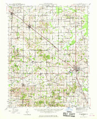
1942 Map of McLeansboro
USGS Topo · Published 1961About this map
The county seat of Mc Leansboro serves as the primary hub of this Southern Illinois landscape during the early 1940s. The region is defined by a dense network of rural infrastructure, where nearly every section of land is anchored by a local schoolhouse or church. Small settlements like Dahlgren, Belle Rive, and the Catholic community of Piopolis are connected by the Louisville and Nashville railroad, which cuts diagonally through the terrain.
Find a feature on this map
83 named features on this map. Tap any name to fly to it.
Don’t see what you’re looking for? This feature index may not catch every label — zoom into the map to look around manually.
Map Details
Editions of this 1942 McLeansboro Map
2 editions found
Other maps of this area

1905 · Eldorado
USGS Topo · 1:62,500

1906 · Eldorado
USGS Topo · 1:62,500

1908 · Galatia
USGS Topo · 1:62,500

1909 · West Frankfort
USGS Topo · 1:62,500

1933 · Mount Vernon
USGS Topo · 1:48,000

1938 · Galatia
USGS Topo · 1:62,500

1939 · Ina
USGS Topo · 1:62,500

1940 · Mount Vernon
USGS Topo · 1:62,500

1941 · West Frankfort
USGS Topo · 1:62,500

1941 · Enfield
USGS Topo · 1:62,500