
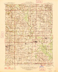
1947 Map of Wayne City
USGS Topo · Published 1947About this map
Wayne City and the surrounding agricultural landscape of Wayne and Jefferson counties are depicted here in the mid-1940s, just as the region’s rural school and church networks remained the center of community life. The Southern railway corridor dictates the placement of settlements like Sims and Keenes, while the Illinois Central Railroad serves Bluford in the west. This survey provides an exceptional view of the southern Illinois prairie before the consolidation of rural districts, shown through dozens of named one-room schoolhouses such as Webber Grove Sch, South Lilly Sch, and Pine Knot Sch.
Find a feature on this map
113 named features on this map. Tap any name to fly to it.
Don’t see what you’re looking for? This feature index may not catch every label — zoom into the map to look around manually.
Map Details
Editions of this 1947 Wayne City Map
3 editions found
Other maps of this area

1933 · Mount Vernon
USGS Topo · 1:48,000

1934 · Salem
USGS Topo · 1:62,500

1938 · Salem
USGS Topo · 1:62,500

1939 · Ina
USGS Topo · 1:62,500

1940 · Mount Vernon
USGS Topo · 1:62,500

1941 · Enfield
USGS Topo · 1:62,500

1942 · McLeansboro
USGS Topo · 1:62,500

1943 · Ina
USGS Topo · 1:62,500

1944 · Enfield
USGS Topo · 1:62,500

1945 · McLeansboro
USGS Topo · 1:62,500