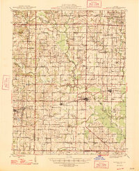
1947 Map of Wayne City
USGS Topo · Published 1947About this map
The Southern railroad corridor serves as the primary East-West artery for this mid-century Illinois landscape, connecting the bustling village of Wayne City with neighboring Keenes and Bluford. The terrain is defined by the winding course of Skillet Fork and its numerous tributaries, including Fourmile Creek and Horse Creek, which carved through the agricultural reaches of Arrington Prairie and Round Prairie. The map documents a dense network of early rural infrastructure, evidenced by dozens of named country schools and churches that served as community anchors before modern consolidation.
Find a feature on this map
99 named features on this map. Tap any name to fly to it.
Don’t see what you’re looking for? This feature index may not catch every label — zoom into the map to look around manually.
Map Details
Editions of this 1947 Wayne City Map
3 editions found

Other maps of this area

1933 · Mount Vernon
USGS Topo · 1:48,000

1934 · Salem
USGS Topo · 1:62,500

1938 · Salem
USGS Topo · 1:62,500

1939 · Ina
USGS Topo · 1:62,500

1940 · Mount Vernon
USGS Topo · 1:62,500

1941 · Enfield
USGS Topo · 1:62,500

1942 · McLeansboro
USGS Topo · 1:62,500

1943 · Ina
USGS Topo · 1:62,500

1944 · Enfield
USGS Topo · 1:62,500

1945 · McLeansboro
USGS Topo · 1:62,500