Old Maps of Wayne County, Illinois
Explore 102 old maps of Wayne County, spanning from 1943 to today. These high-resolution historic maps reveal how streets, neighborhoods, landmarks, and natural features evolved over time — perfect for genealogy, metal detecting, research, and local history exploration.
What you can do with these maps:
- See how Wayne County changed over time: Compare historical maps to modern-day views to trace roads, homesites, rail lines & more.
- View detailed metadata: Each map includes creators, publishers, year, scale, and archive source.
- Overlay maps with satellite & LiDAR: Visualize the past alongside modern tools to explore terrain & human change.
- Trusted historical sources: Maps sourced from the USGS, Library of Congress, and other archives.
- Access maps your way: View online, download high-res files, or order prints for personal or research use.
Start exploring old maps of Wayne County to uncover forgotten places, hidden landmarks, and the deep history beneath your feet.
Wayne County, IL maps
(102)- 1943 Map of Albion, 1969 Print
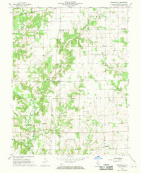
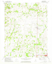
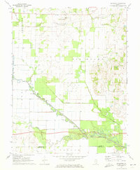
 1943 Albion1969 Print · USGSEdwards County and its neighbors are captured here in the 1940s, showing a landscape defined by the winding Little Wabash River and the Southern rail line. Genealogists can locate numerous rural landmarks like Wanbor Cem, Samsville, and the Curtisville Sch.
 - 1946 Map of Albion
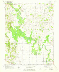
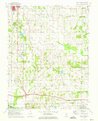
 1946 Albion1946 Print · USGSEdwards and Wayne Counties are shown in the mid-1940s as a thriving network of rural school districts and small rail towns. Genealogists can trace family homesteads near Albion and Bone Gap or locate vanished landmarks like Blacks Store and Beech Bluff Sch.
 - 1947 Map of Wayne City
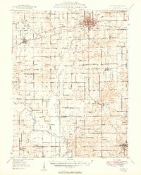
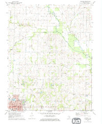
 1947 Wayne City1947 Print · USGSSouthern Illinois in the mid-1940s is captured here at a time when small rural schools and country churches still defined the local geography. Researchers can trace the rail-centered growth of Wayne City and Bluford or locate family sites like Garrison Temple, Thomason Cem, and Berry Sch.3 unique versions available
 - 1948 Map of Fairfield
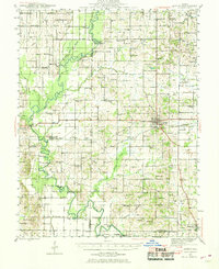
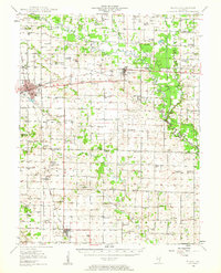
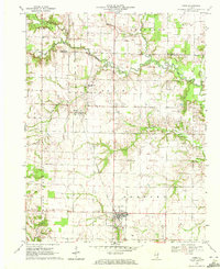
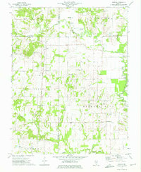
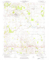
 1948 Fairfield1948 Print · USGSWayne County is captured in the late 1940s as a thriving network of small rail towns and rural school districts. Genealogists and historians can trace family locations near Pure Gold Sch, the Crews Cem, or the rail junction at Fairfield.2 unique versions available
 - 1948 Map of Flora, 1963 Print
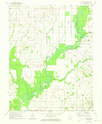
 1948 Flora1963 Print · USGSClay and Wayne counties are shown at their mid-century peak of rural development, centered on the BALTIMORE AND OHIO RR corridor. Local historians can trace dozens of vanished schoolhouses and country churches, from West Seminary Sch to the South Freedom Ch.
 - 1949 Map of Olney
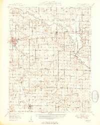
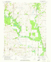
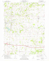
 1949 Olney1949 Print · USGSSoutheastern Illinois in the late 1940s is a landscape of thriving rail hubs and scattered oil wells. Genealogists can locate family names and rural landmarks like Sodom Sch, Shields Cem, and the Baltimore and Ohio RR corridor.2 unique versions available
 - 1949 Map of Flora
 1949 Flora1949 Print · USGSSouthern Illinois during the late 1940s was a landscape defined by the winding Little Wabash River and the busy Baltimore and Ohio RR. Researchers can trace the cultural roots of the region through dozens of local landmarks like Lathrop Chapel, Long Prairie Sch, and Oil Wells near Cisne.2 unique versions available
 - 1952 Map of Xenia, 1954 Print
 1952 Xenia1954 Print · USGSSouthern Illinois prairie and farmland are captured here in the early fifties, showing the rural crossroads of Clay and Wayne Counties. Researchers can trace dozens of country schools and family landmarks like Henson Cem, Vickrey Sch, and the Baltimore and Ohio rail line.2 unique versions available
 - 1958 Map of Belleville, 1973 Print
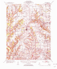
 1958 Belleville1973 Print · USGSSouthern Illinois during the mid-twentieth century reveals a landscape of industrial growth and massive new reservoirs. Genealogists and historians can trace the paths of the Illinois Central RR through towns like Centralia or locate landmarks such as Emerald Mound and the Looking Glass Prairie.3 unique versions available
 - 1962 Map of Belleville
 1962 Belleville1962 Print · USGSSouthern Illinois in the late fifties reveals a landscape of industrial growth and ancient landmarks before the full expansion of the interstate system. Genealogists can trace family names and rural post offices near Centralia, Salem, and the historic Monks Mound.
 - 1968 Map of Orchardville, 1970 Print
 1968 Orchardville1970 Print · USGSSouthern Illinois rural life remains visible in the late sixties as the towns of Orchardville and Helm anchor a landscape of family farms. Genealogists can trace deep roots through numerous sites like Burroughs Cem and New Liberty Ch.
 - 1968 Map of Johnsonville, 1970 Print
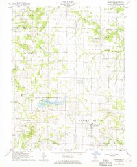 1968 Johnsonville1970 Print · USGSWayne County in the late 1960s reveals a rural landscape dominated by oil production and state conservation efforts. Trace family history at Johnsonville Cem and Wesley Cem or explore the growth of the Johnsonville Oil Field.2 unique versions available
 - 1970 Map of Enterprise, 1971 Print
 1970 Enterprise1971 Print · USGSWayne and Clay counties are shown here in the 1970s, a period when the local economy was shaped by the Clay City Oil Field and river bottom farming. Researchers can locate numerous family burial sites and rural landmarks like Enterprise, Laird Cem, and Patterson Ch.
 - 1970 Map of Cisne, 1972 Print
 1970 Cisne1972 Print · USGSCisne and the surrounding Wayne County countryside are captured here in the early 1970s, showcasing a landscape where the railroad and oil industry met. Genealogists and local historians can locate several rural burial grounds like Stine Cem and Madden Cem or trace the Baltimore and Ohio rail line past Rinard.
 - 1970 Map of Geff, 1973 Print
 1970 Geff1973 Print · USGSWayne County oil production and rural settlement meet in the early seventies, centered on the community of Geff. Genealogists can locate family landmarks like Young Cem and Oak Valley Ch amidst the active Clay City Oil Field.
 - 1971 Map of Golden Gate, 1973 Print
 1971 Golden Gate1973 Print · USGSSoutheastern Illinois in the early 1970s is characterized by the winding oxbows of the Little Wabash River and active riverfront industry. Genealogists can trace several family burial sites including Wilson Cem and Stewart Cem, while historians can locate the Old Iron Bridge and Southern Railway corridor.
 - 1971 Map of Albion NW, 1973 Print
 1971 Albion NW1973 Print · USGSSoutheastern Illinois farm life and the oil industry intersect along the Little Wabash River in the early 1970s. Researchers can locate family landmarks like Locust Grove Cem and McKendree Chapel, or trace the development of the Maple Grove Oil Field.
 - 1971 Map of Mount Erie, 1973 Print
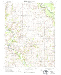
 1971 Mount Erie1973 Print · USGSWayne County settlement centers on the high ground near Mount Erie in the early 1970s, while the Little Wabash River meanders through the bottomlands. Researchers can trace rural lineages through numerous local sites like Wynoose Cem, Forest Ridge Ch, and the crossroads at Bennington.2 unique versions available
 - 1971 Map of Boyleston, 1973 Print
 1971 Boyleston1973 Print · USGSSouthern Illinois farming and drainage systems are in full view here in the early 1970s. Genealogists and historians can trace family burial sites like Clark Cem, rural schools like Boyleston Sch, and the winding path of the Skillet Fork.
 - 1971 Map of Burnt Prairie, 1973 Print
 1971 Burnt Prairie1973 Print · USGSSoutheastern Illinois reveals a landscape of active petroleum extraction and family homesteads in the early seventies. Genealogists and historians can trace numerous rural burial grounds like Koontz Cem and Gifford Cem alongside the heavy rail presence of the Baltimore and Ohio RR.
 - 1971 Map of Fairfield, 1973 Print
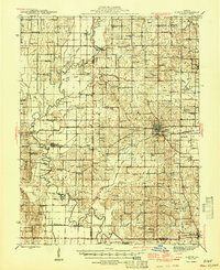
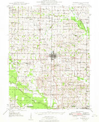
 1971 Fairfield1973 Print · USGSFairfield and the surrounding Illinois prairie are captured here in the early seventies during a period of steady industrial and agricultural activity. Genealogists can trace family names through numerous rural landmarks like North Toms Prairie Ch, Hearn Cem, and Butler Bridge.
 - 1973 Map of Shields, 1975 Print
 1973 Shields1975 Print · USGSWayne and Jefferson counties come alive in the early seventies, showing a landscape defined by the Orchardville Oil Field and rural river crossings. Trace family roots at the McConaughhay Cem, locate the old Ten Foot Oak Ch, or follow the Skillet Fork to Greathouse Ford.
 - 1973 Map of Wayne City, 1975 Print
 1973 Wayne City1975 Print · USGSSouthern Illinois in the early 1970s shows a landscape of small rail-side villages and rural cemeteries along the Skillet Fork. Genealogists can trace family roots at Baltimore Cem or locate the old Oak Grove Sch near Mayberry.
 - 1973 Map of Bluford, 1975 Print
 1973 Bluford1975 Print · USGSJefferson and Wayne Counties appear here in the early 1970s as centers of rail transport and petroleum production. Researchers can trace family history through landmarks like Long Prairie Cem, Bluford Sch, and the Markham City Oil Field.2 unique versions available
 - 1973 Map of Crisp, 1975 Print
 1973 Crisp1975 Print · USGSWayne County farmland and oil fields are captured here in the early seventies, showing a landscape defined by small settlements and family plots. Trace rural roots at Crisp or locate ancestral sites like Anderson Cem and the New Zion Ch.
Showing maps 1-25 of 102
Top cities of Wayne County
- Fairfield historical maps
- Wayne City historical maps
- Barnhill historical maps
- Sims historical maps
- Mount Erie historical maps
- Keenes historical maps
See more
Frequently asked questions
- What are the different types of historical maps available for Wayne County?
- What is the oldest map of Wayne County?
- Where can I purchase historical maps of Wayne County for my home or office?
- Where can I download high-res historical maps of Wayne County?
- Are there historical topographic maps available for Wayne County?
- Is there historical aerial imagery available for Wayne County?
- Where are historical maps of Wayne County sourced from?