Loading...
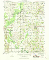
Loading map...1943 Map of Albion
USGS Topo · Published 1969About this map
The Little Wabash River defines the western reaches of this mid-century landscape, where a complex system of oxbows and sloughs like Ash Slough and White Oak Slough suggest the dynamic nature of the river valley. In the center of the sheet, Albion serves as a primary hub for the Southern railroad line, which connects the county seat to smaller agricultural settlements such as Bone Gap and Golden Gate.
Find a feature on this map
91 named features on this map. Tap any name to fly to it.
Don’t see what you’re looking for? This feature index may not catch every label — zoom into the map to look around manually.
Map Details
Date Portrayed1943
Date Published1969
PublisherU.S. Geological Survey
Map TypeTopographic
Scale1:62,500
Physical Dimensions17 x 20.8 inches
Editions of this 1943 Albion Map
This is the sole edition of this map. No revisions or reprints were ever made.
Historical Maps of Albion Through Time
Featured Locations
Source Details
SourceU.S. Geological Survey
CopyrightPublic Domain