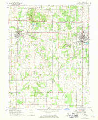
1913 Map of Sumner
USGS Topo · Published 1913About this map
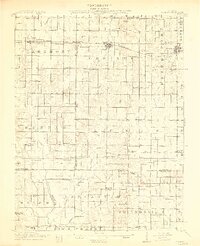
The Baltimore and Ohio Southwestern railroad serves as the primary east-west corridor for this early 20th-century landscape, linking the established settlements of Sumner and Bridgeport. Near the eastern margin, industrial development is evident via the Oil Tanks located south of Bridgeport, signaling the era's regional economic activity. The map is exceptionally dense with rural educational history, identifying dozens of local schoolhouses such as Pinhook School, Buckhorn School, Frogeye School, and Victory School, which are distributed at roughly two-mile intervals across the townships.
Find a feature on this map
81 named features on this map. Tap any name to fly to it.
Don’t see what you’re looking for? This feature index may not catch every label — zoom into the map to look around manually.
Map Details
Editions of this 1913 Sumner Map
2 editions found
Historical Maps of Bridgeport Through Time
8 maps found