1970s Maps of Wayne County, Illinois
Explore 13 historic maps of Wayne County from the 1970s. These maps offer a rare glimpse into what life looked like during the 1970s — showing old roads, neighborhoods, homes, and landmarks that have changed or disappeared over time.
Whether you're researching your family's past, planning a metal detecting trip, or studying how Wayne County's landscape evolved across the 1970s, these high-resolution maps are a powerful tool for exploring the history of this region.
- Focus on a specific era: All maps on this page are from the 1970s, giving you a focused view of this time period.
- See what’s changed: Compare century-old streets, trails, and buildings to today's modern landscape using overlays and satellite layers.
- Research with precision: Use these maps for genealogy, historical research, land use analysis, or educational projects.
- View, download, or print: Maps are fully viewable online in high resolution, and can be downloaded or printed for your own records.
Start exploring Wayne County's history through authentic maps from the 1970s. This is your window into the past.
Wayne County, IL maps
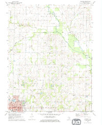
(13)- 1970 Map of Enterprise, 1971 Print
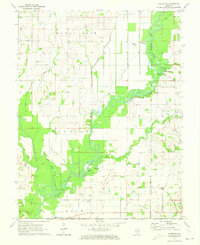
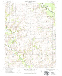 1970 Enterprise1971 Print · USGSWayne and Clay counties are shown here in the 1970s, a period when the local economy was shaped by the Clay City Oil Field and river bottom farming. Researchers can locate numerous family burial sites and rural landmarks like Enterprise, Laird Cem, and Patterson Ch.
 - 1970 Map of Cisne, 1972 Print
 1970 Cisne1972 Print · USGSCisne and the surrounding Wayne County countryside are captured here in the early 1970s, showcasing a landscape where the railroad and oil industry met. Genealogists and local historians can locate several rural burial grounds like Stine Cem and Madden Cem or trace the Baltimore and Ohio rail line past Rinard.
 - 1970 Map of Geff, 1973 Print
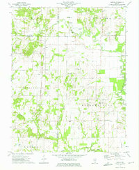
 1970 Geff1973 Print · USGSWayne County oil production and rural settlement meet in the early seventies, centered on the community of Geff. Genealogists can locate family landmarks like Young Cem and Oak Valley Ch amidst the active Clay City Oil Field.
 - 1971 Map of Golden Gate, 1973 Print
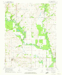
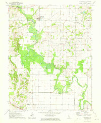 1971 Golden Gate1973 Print · USGSSoutheastern Illinois in the early 1970s is characterized by the winding oxbows of the Little Wabash River and active riverfront industry. Genealogists can trace several family burial sites including Wilson Cem and Stewart Cem, while historians can locate the Old Iron Bridge and Southern Railway corridor.
 - 1971 Map of Albion NW, 1973 Print
 1971 Albion NW1973 Print · USGSSoutheastern Illinois farm life and the oil industry intersect along the Little Wabash River in the early 1970s. Researchers can locate family landmarks like Locust Grove Cem and McKendree Chapel, or trace the development of the Maple Grove Oil Field.
 - 1971 Map of Mount Erie, 1973 Print
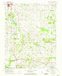
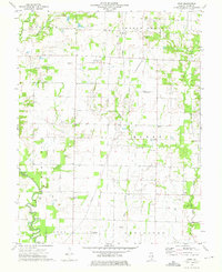
 1971 Mount Erie1973 Print · USGSWayne County settlement centers on the high ground near Mount Erie in the early 1970s, while the Little Wabash River meanders through the bottomlands. Researchers can trace rural lineages through numerous local sites like Wynoose Cem, Forest Ridge Ch, and the crossroads at Bennington.2 unique versions available
 - 1971 Map of Boyleston, 1973 Print
 1971 Boyleston1973 Print · USGSSouthern Illinois farming and drainage systems are in full view here in the early 1970s. Genealogists and historians can trace family burial sites like Clark Cem, rural schools like Boyleston Sch, and the winding path of the Skillet Fork.
 - 1971 Map of Burnt Prairie, 1973 Print
 1971 Burnt Prairie1973 Print · USGSSoutheastern Illinois reveals a landscape of active petroleum extraction and family homesteads in the early seventies. Genealogists and historians can trace numerous rural burial grounds like Koontz Cem and Gifford Cem alongside the heavy rail presence of the Baltimore and Ohio RR.
 - 1971 Map of Fairfield, 1973 Print
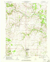
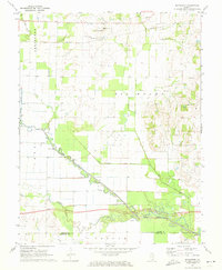
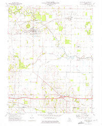
 1971 Fairfield1973 Print · USGSFairfield and the surrounding Illinois prairie are captured here in the early seventies during a period of steady industrial and agricultural activity. Genealogists can trace family names through numerous rural landmarks like North Toms Prairie Ch, Hearn Cem, and Butler Bridge.
 - 1973 Map of Shields, 1975 Print
 1973 Shields1975 Print · USGSWayne and Jefferson counties come alive in the early seventies, showing a landscape defined by the Orchardville Oil Field and rural river crossings. Trace family roots at the McConaughhay Cem, locate the old Ten Foot Oak Ch, or follow the Skillet Fork to Greathouse Ford.
 - 1973 Map of Wayne City, 1975 Print
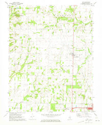
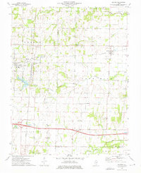
 1973 Wayne City1975 Print · USGSSouthern Illinois in the early 1970s shows a landscape of small rail-side villages and rural cemeteries along the Skillet Fork. Genealogists can trace family roots at Baltimore Cem or locate the old Oak Grove Sch near Mayberry.
 - 1973 Map of Bluford, 1975 Print
 1973 Bluford1975 Print · USGSJefferson and Wayne Counties appear here in the early 1970s as centers of rail transport and petroleum production. Researchers can trace family history through landmarks like Long Prairie Cem, Bluford Sch, and the Markham City Oil Field.2 unique versions available
 - 1973 Map of Crisp, 1975 Print
 1973 Crisp1975 Print · USGSWayne County farmland and oil fields are captured here in the early seventies, showing a landscape defined by small settlements and family plots. Trace rural roots at Crisp or locate ancestral sites like Anderson Cem and the New Zion Ch.
End of results
Showing maps 1-13 of 13
Top cities of Wayne County
- Fairfield historical maps
- Wayne City historical maps
- Barnhill historical maps
- Sims historical maps
- Mount Erie historical maps
- Keenes historical maps
See more
Frequently asked questions
- What are the different types of historical maps available for Wayne County?
- What is the oldest map of Wayne County?
- Where can I purchase historical maps of Wayne County for my home or office?
- Where can I download high-res historical maps of Wayne County?
- Are there historical topographic maps available for Wayne County?
- Is there historical aerial imagery available for Wayne County?
- Where are historical maps of Wayne County sourced from?