1910s Maps of La Harpe, Illinois
Explore 1 historic maps of La Harpe from the 1910s. These maps offer a rare glimpse into what life looked like during the 1910s — showing old roads, neighborhoods, homes, and landmarks that have changed or disappeared over time.
Whether you're researching your family's past, planning a metal detecting trip, or studying how La Harpe's landscape evolved across the 1910s, these high-resolution maps are a powerful tool for exploring the history of this region.
- Focus on a specific era: All maps on this page are from the 1910s, giving you a focused view of this time period.
- See what’s changed: Compare century-old streets, trails, and buildings to today's modern landscape using overlays and satellite layers.
- Research with precision: Use these maps for genealogy, historical research, land use analysis, or educational projects.
- View, download, or print: Maps are fully viewable online in high resolution, and can be downloaded or printed for your own records.
Start exploring La Harpe's history through authentic maps from the 1910s. This is your window into the past.
La Harpe, IL maps
(1)- 1918 Map of La Harpe
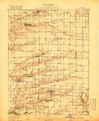 1918 La Harpe1918 Print · USGSWestern Illinois farm life in the late teens is captured here through a remarkably dense grid of rural schools and rail-fed townships. Genealogists can trace family footprints across dozens of local districts like Sunny Ridge School and Waggy School or along the Santa Fe line.4 unique versions available
End of results
Showing maps 1-1 of 1
Top cities near La Harpe
- Burlington historical maps
- Macomb historical maps
- Carthage historical maps
- Colchester historical maps
- Dallas City historical maps
- Stronghurst historical maps
See more
Frequently asked questions
- What are the different types of historical maps available for La Harpe?
- What is the oldest map of La Harpe?
- Where can I purchase historical maps of La Harpe for my home or office?
- Where can I download high-res historical maps of La Harpe?
- Are there historical topographic maps available for La Harpe?
- Is there historical aerial imagery available for La Harpe?
- Where are historical maps of La Harpe sourced from?