1990s Maps of Atkinson, Illinois
Explore 1 historic maps of Atkinson from the 1990s. These maps offer a rare glimpse into what life looked like during the 1990s — showing old roads, neighborhoods, homes, and landmarks that have changed or disappeared over time.
Whether you're researching your family's past, planning a metal detecting trip, or studying how Atkinson's landscape evolved across the 1990s, these high-resolution maps are a powerful tool for exploring the history of this region.
- Focus on a specific era: All maps on this page are from the 1990s, giving you a focused view of this time period.
- See what’s changed: Compare century-old streets, trails, and buildings to today's modern landscape using overlays and satellite layers.
- Research with precision: Use these maps for genealogy, historical research, land use analysis, or educational projects.
- View, download, or print: Maps are fully viewable online in high resolution, and can be downloaded or printed for your own records.
Start exploring Atkinson's history through authentic maps from the 1990s. This is your window into the past.
Atkinson, IL maps
(1)- 1991 Map of Atkinson, 1992 Print
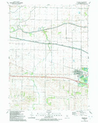 1991 Atkinson1992 Print · USGSThe village of Atkinson and the surrounding Illinois prairie are shown here in the early nineties as the region maintained its deep agricultural and water-management roots. Researchers can trace family history at St Anthony Cem, locate the Spring Creek Grange Hall, or follow the path of the Hennepin Canal.
End of results
Showing maps 1-1 of 1
Top cities near Atkinson
- Kewanee historical maps
- Geneseo historical maps
- Cambridge historical maps
- Osceola historical maps
- Annawan historical maps
- Tampico historical maps
See more
Frequently asked questions
- What are the different types of historical maps available for Atkinson?
- What is the oldest map of Atkinson?
- Where can I purchase historical maps of Atkinson for my home or office?
- Where can I download high-res historical maps of Atkinson?
- Are there historical topographic maps available for Atkinson?
- Is there historical aerial imagery available for Atkinson?
- Where are historical maps of Atkinson sourced from?