1940s Maps of Woodhull, Illinois
Explore 1 historic maps of Woodhull from the 1940s. These maps offer a rare glimpse into what life looked like during the 1940s — showing old roads, neighborhoods, homes, and landmarks that have changed or disappeared over time.
Whether you're researching your family's past, planning a metal detecting trip, or studying how Woodhull's landscape evolved across the 1940s, these high-resolution maps are a powerful tool for exploring the history of this region.
- Focus on a specific era: All maps on this page are from the 1940s, giving you a focused view of this time period.
- See what’s changed: Compare century-old streets, trails, and buildings to today's modern landscape using overlays and satellite layers.
- Research with precision: Use these maps for genealogy, historical research, land use analysis, or educational projects.
- View, download, or print: Maps are fully viewable online in high resolution, and can be downloaded or printed for your own records.
Start exploring Woodhull's history through authentic maps from the 1940s. This is your window into the past.
Woodhull, IL maps
(1)- 1947 Map of Woodhull
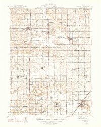 1947 Woodhull1947 Print · USGSThe Illinois prairie at mid-century reveals a dense network of family farms and rural institutions near the Henry and Knox county lines. Genealogists can trace ancestral sites through dozens of named schools and cemeteries like Prairie Flower Sch and Oxford Cem.2 unique versions available
End of results
Showing maps 1-1 of 1
Top cities near Woodhull
- Galesburg historical maps
- Cambridge historical maps
- Orion historical maps
- Ontario historical maps
- Wataga historical maps
- East Galesburg historical maps
See more
Frequently asked questions
- What are the different types of historical maps available for Woodhull?
- What is the oldest map of Woodhull?
- Where can I purchase historical maps of Woodhull for my home or office?
- Where can I download high-res historical maps of Woodhull?
- Are there historical topographic maps available for Woodhull?
- Is there historical aerial imagery available for Woodhull?
- Where are historical maps of Woodhull sourced from?