1950s Maps of Jersey County, Illinois
Explore 9 historic maps of Jersey County from the 1950s. These maps offer a rare glimpse into what life looked like during the 1950s — showing old roads, neighborhoods, homes, and landmarks that have changed or disappeared over time.
Whether you're researching your family's past, planning a metal detecting trip, or studying how Jersey County's landscape evolved across the 1950s, these high-resolution maps are a powerful tool for exploring the history of this region.
- Focus on a specific era: All maps on this page are from the 1950s, giving you a focused view of this time period.
- See what’s changed: Compare century-old streets, trails, and buildings to today's modern landscape using overlays and satellite layers.
- Research with precision: Use these maps for genealogy, historical research, land use analysis, or educational projects.
- View, download, or print: Maps are fully viewable online in high resolution, and can be downloaded or printed for your own records.
Start exploring Jersey County's history through authentic maps from the 1950s. This is your window into the past.
Jersey County, IL maps
(9)- 1950 Map of Alton
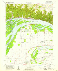
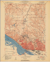 1950 Alton1950 Print · USGSAlton was a bustling river and rail hub at the mid-century, defined by its educational institutions and heavy river infrastructure. Trace the old campus of Western Military Academy, the riverfront at Lock and Dam No 26, and cemeteries like Confederate Cem.2 unique versions available
 - 1954 Map of Elsah, 1959 Print
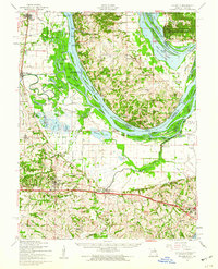
 1954 Elsah1959 Print · USGSThe river bluffs of Jersey and Madison counties are captured here in the mid-fifties as river life and rail commerce intersected. Researchers can trace the grounds of Principia College, the streets of Portage Des Sioux, and defunct rural sites like Mertz Sch.3 unique versions available
 - 1954 Map of Brussels, 1959 Print
 1954 Brussels1959 Print · USGSThe peninsula of Calhoun County in the mid-1950s is defined by its position between the Mississippi and Illinois Rivers. Genealogists and historians can trace old river life through Brussels, rural schools like Fruitland Sch, and sites like Lone Tree Indian Mound.3 unique versions available
 - 1954 Map of Alton, 1959 Print
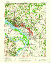
 1954 Alton1959 Print · USGSMid-century Alton and Godfrey thrive as centers of education and industry along the Mississippi. Researchers can trace the grounds of Monticello College, locate the Confederate Cem, and follow the Gulf Mobile and Ohio rail lines.4 unique versions available
 - 1954 Map of Grafton, 1959 Print
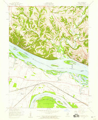
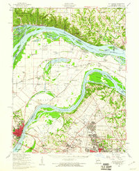
 1954 Grafton1959 Print · USGSThe confluence of the Illinois and Mississippi Rivers is captured here in the mid-1950s, showing a landscape defined by dramatic bluffs and low-lying chutes. Genealogists can locate family landmarks like Scenic Hill Cem and old country schoolhouses such as Pleasant Union Sch and Lake View Sch.4 unique versions available
 - 1954 Map of Brussels, 1960 Print
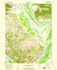
 1954 Brussels1960 Print · USGSThe confluence of the Mississippi and Illinois Rivers comes alive in the mid-1950s, showing a landscape shaped by river transport and rail. Trace the routes of the Wabash Railroad or find family history at All Saints Village and Dardenne Cem.2 unique versions available
 - 1954 Map of St. Charles, 1960 Print
 1954 St. Charles1960 Print · USGSThe river confluence near St. Louis during the mid-fifties reveals a landscape balancing traditional river life with rapid suburban and aviation growth. Genealogists and historians can trace family roots through sites like St Stanislaus Seminary Cem, Portage Des Sioux, and the campus of Principia College.2 unique versions available
 - 1955 Map of Alton, 1960 Print
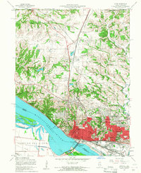
 1955 Alton1960 Print · USGSThe industrial riverfronts and expanding rail corridors of the Metro East are captured here in the mid-fifties. Researchers can trace the development of Alton State Hospital, the grounds of Monticello College, and historic sites like Fort Bellefontaine.2 unique versions available
 - 1956 Map of Quincy, 1967 Print
 1956 Quincy1967 Print · USGSThe river and rail corridors of the Illinois-Missouri border are documented here during the mid-1950s. Researchers can trace historic river landings and regional transit hubs from Quincy and Hannibal to smaller settlements like Meredosia and Roodhouse.3 unique versions available
End of results
Showing maps 1-9 of 9
Top cities of Jersey County
- Jerseyville historical maps
- Grafton historical maps
- Elsah historical maps
- Rosedale historical maps
- Fieldon historical maps
- Otterville historical maps
See more
Frequently asked questions
- What are the different types of historical maps available for Jersey County?
- What is the oldest map of Jersey County?
- Where can I purchase historical maps of Jersey County for my home or office?
- Where can I download high-res historical maps of Jersey County?
- Are there historical topographic maps available for Jersey County?
- Is there historical aerial imagery available for Jersey County?
- Where are historical maps of Jersey County sourced from?