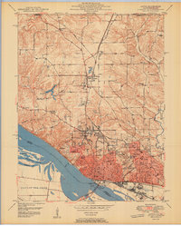
1950 Map of Alton
USGS Topo · Published 1950About this map
The Mississippi River defines the southern edge of this mid-century landscape, where industrial and educational institutions anchor the river-bluff city. Notable for its dense concentration of private and state facilities, the area includes the Western Military Academy, Shurtleff College, and the sprawling State Hospital grounds. Along the riverfront, infrastructure dominates the shoreline with Lock and Dam No 26 and the Lewis and Clark Toll Bridge providing critical crossings for regional commerce. North of the urban center, the terrain transitions into a patchwork of rural schools and seminaries, such as Monticello Seminary and South Branch Sch. The map reveals a complex rail network serving the river valley, including the Gulf Mobile and Ohio and Illinois Terminal lines, which supported the industry and limestone quarrying common to the bluffs. Local history is further preserved through numerous burial grounds like Confederate Cem and Valhalla Cem.
Find a feature on this map
58 named features on this map. Tap any name to fly to it.
Don’t see what you’re looking for? This feature index may not catch every label — zoom into the map to look around manually.
Map Details
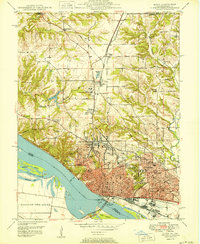
Editions of this 1950 Alton Map
2 editions found
Other maps of this area

1925 · Brighton
USGS Topo · 1:62,500

1927 · Alton
USGS Topo · 1:62,500

1927 · St. Charles
USGS Topo · 1:62,500

1928 · Brighton
USGS Topo · 1:62,500

1930 · Jerseyville
USGS Topo · 1:62,500

1933 · Jerseyville
USGS Topo · 1:62,500

1933 · Saint Charles
USGS Topo · 1:62,500

1934 · Alton
USGS Topo · 1:62,500

1935 · Florissant
USGS Topo · 1:24,000

1935 · Columbia Bottom
USGS Topo · 1:24,000