1960s Maps of Thompson Township, Illinois
Explore 6 historic maps of Thompson Township from the 1960s. These maps offer a rare glimpse into what life looked like during the 1960s — showing old roads, neighborhoods, homes, and landmarks that have changed or disappeared over time.
Whether you're researching your family's past, planning a metal detecting trip, or studying how Thompson Township's landscape evolved across the 1960s, these high-resolution maps are a powerful tool for exploring the history of this region.
- Focus on a specific era: All maps on this page are from the 1960s, giving you a focused view of this time period.
- See what’s changed: Compare century-old streets, trails, and buildings to today's modern landscape using overlays and satellite layers.
- Research with precision: Use these maps for genealogy, historical research, land use analysis, or educational projects.
- View, download, or print: Maps are fully viewable online in high resolution, and can be downloaded or printed for your own records.
Start exploring Thompson Township's history through authentic maps from the 1960s. This is your window into the past.
Thompson Township, IL maps
(6)- 1961 Map of Dubuque
 1961 Dubuque1961 Print · USGSThe Tri-State region's river-and-rail landscape is captured here during the early sixties, showing the convergence of Iowa, Illinois, and Wisconsin. Trace mid-century rail lines like the Chicago Great Western Ry and explore sites like the Savanna Ordnance Depot and Backbone State Park.
 - 1962 Map of Dubuque
 1962 Dubuque1962 Print · USGSThe Tri-State region's river-and-rail economy is captured here in the early sixties, centered on the Mississippi River bluffs. Genealogists and historians can locate Numerous lead and zinc mines, the New Melleray Abbey Monastery, and rural hubs like Saint Olaf.2 unique versions available
 - 1968 Map of Elizabeth NE, 1970 Print
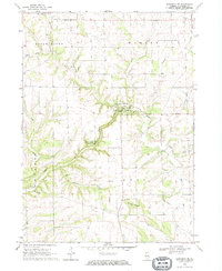 1968 Elizabeth NE1970 Print · USGSUpper Illinois in the late sixties reveals a landscape of limestone bluffs and quiet rural townships. Researchers can trace the history of family plots and vanished hamlets through sites like Millville, Thompson Cem, and the high peak of Benton Mound.
 - 1968 Map of Stockton, 1970 Print
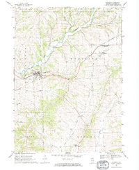
 1968 Stockton1970 Print · USGSJo Daviess County at the end of the sixties shows a landscape defined by the Chicago and North Western rail line and the Plum River valley. Researchers can trace rural lineages through the Townsend Cem, St John Ch, and the settlement at Elmoville.
 - 1968 Map of Elizabeth, 1970 Print
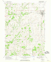
 1968 Elizabeth1970 Print · USGSThe rolling hills of Jo Daviess County come into focus during the late sixties as the rail lines shaped local trade. Researchers can trace family sites near Elizabeth, Woodbine, and Derinda Center, alongside landmarks like St Marys Cem and the Bible Ch.
 - 1968 Map of Scales Mound East, 1971 Print
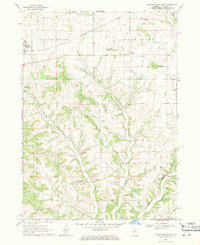 1968 Scales Mound East1971 Print · USGSJo Daviess County in the late sixties shows a landscape of high ridges and driftless valleys defined by the Illinois Central railroad. Genealogists can trace the rural community of Schapville and several unnamed cemeteries near Hells Branch.2 unique versions available
End of results
Showing maps 1-6 of 6
Top cities near Thompson Township
- Stockton historical maps
- Warren historical maps
- Shullsburg historical maps
- Benton historical maps
- Guilford historical maps
- Wiota historical maps
See more
Top neighborhoods of Thompson Township
Frequently asked questions
- What are the different types of historical maps available for Thompson Township?
- What is the oldest map of Thompson Township?
- Where can I purchase historical maps of Thompson Township for my home or office?
- Where can I download high-res historical maps of Thompson Township?
- Are there historical topographic maps available for Thompson Township?
- Is there historical aerial imagery available for Thompson Township?
- Where are historical maps of Thompson Township sourced from?