1910s Maps of Simpson, Illinois
Explore 3 historic maps of Simpson from the 1910s. These maps offer a rare glimpse into what life looked like during the 1910s — showing old roads, neighborhoods, homes, and landmarks that have changed or disappeared over time.
Whether you're researching your family's past, planning a metal detecting trip, or studying how Simpson's landscape evolved across the 1910s, these high-resolution maps are a powerful tool for exploring the history of this region.
- Focus on a specific era: All maps on this page are from the 1910s, giving you a focused view of this time period.
- See what’s changed: Compare century-old streets, trails, and buildings to today's modern landscape using overlays and satellite layers.
- Research with precision: Use these maps for genealogy, historical research, land use analysis, or educational projects.
- View, download, or print: Maps are fully viewable online in high resolution, and can be downloaded or printed for your own records.
Start exploring Simpson's history through authentic maps from the 1910s. This is your window into the past.
Simpson, IL maps
(3)- 1917 Map of Brownfield
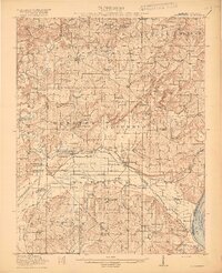 1917 Brownfield1917 Print · USGSSouthern Illinois in the years before the Great War is captured here through its dense network of rural schoolhouses and rail sidings. Researchers can locate family landmarks like Lackey Bridge, Allard College School, and Dixon Springs Sta (Renshaw P.O.).4 unique versions available
 - 1918 Map of Vienna, 1943 Print
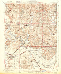 1918 Vienna1943 Print · USGSJohnson and Massac Counties appear here during the height of the steam rail era, centered on the crossroads of VIENNA. Local historians can trace old rural schoolhouses like Taylor School, family sites at Oliver Cemetery, and early settlements such as Ganntown and Samoth.
 - 1919 Map of Vienna
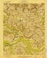 1919 Vienna1919 Print · USGSSouthern Illinois during the late teens reveals a landscape defined by extensive drainage engineering and a high density of rural schools. Genealogists can trace family roots at Oliver Cemetery or locate early rural schoolhouses like Peach School and Whiteside School.
End of results
Showing maps 1-3 of 3
Top cities near Simpson
- Marion historical maps
- Carrier Mills historical maps
- Vienna historical maps
- Goreville historical maps
- Creal Springs historical maps
- Karnak historical maps
See more
Frequently asked questions
- What are the different types of historical maps available for Simpson?
- What is the oldest map of Simpson?
- Where can I purchase historical maps of Simpson for my home or office?
- Where can I download high-res historical maps of Simpson?
- Are there historical topographic maps available for Simpson?
- Is there historical aerial imagery available for Simpson?
- Where are historical maps of Simpson sourced from?