1970s Maps of Kane County, Illinois
Explore 3 historic maps of Kane County from the 1970s. These maps offer a rare glimpse into what life looked like during the 1970s — showing old roads, neighborhoods, homes, and landmarks that have changed or disappeared over time.
Whether you're researching your family's past, planning a metal detecting trip, or studying how Kane County's landscape evolved across the 1970s, these high-resolution maps are a powerful tool for exploring the history of this region.
- Focus on a specific era: All maps on this page are from the 1970s, giving you a focused view of this time period.
- See what’s changed: Compare century-old streets, trails, and buildings to today's modern landscape using overlays and satellite layers.
- Research with precision: Use these maps for genealogy, historical research, land use analysis, or educational projects.
- View, download, or print: Maps are fully viewable online in high resolution, and can be downloaded or printed for your own records.
Start exploring Kane County's history through authentic maps from the 1970s. This is your window into the past.
Kane County, IL maps
(3)- 1971 Map of Plano, 1973 Print
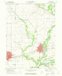 1971 Plano1973 Print · USGSKendall County's river-and-rail corridor is captured here in the early seventies, showing the growth of Plano and Sandwich. Local historians can trace family landmarks and rural infrastructure, from Plano Cem to the Burlington Northern rail line.
 - 1972 Map of Huntley, 1973 Print
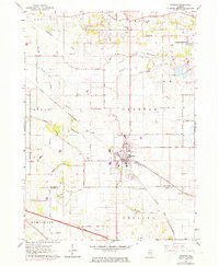 1972 Huntley1973 Print · USGSHuntley and its surrounding townships are shown here in the early seventies as the region balanced its agricultural roots with highway-driven growth. Researchers can locate family landmarks like St Marys Cem, the rural Grange Hall, and the winding Kishwaukee River.
 - 1978 Map of Huntley, 1991 Print
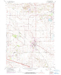 1978 Huntley1991 Print · USGSMcHenry County enters a period of modern growth in the late seventies as industrial routes meet traditional farmsteads. Researchers can trace the legacy of family lands near Coyne or locate old community landmarks like Grange Hall and St Marys Ch.
End of results
Showing maps 1-3 of 3
Top cities of Kane County
- Elgin historical maps
- Batavia historical maps
- Rutland Township historical maps
- South Elgin historical maps
- North Aurora historical maps
Frequently asked questions
- What are the different types of historical maps available for Kane County?
- What is the oldest map of Kane County?
- Where can I purchase historical maps of Kane County for my home or office?
- Where can I download high-res historical maps of Kane County?
- Are there historical topographic maps available for Kane County?
- Is there historical aerial imagery available for Kane County?
- Where are historical maps of Kane County sourced from?