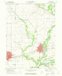
1971 Map of Plano
USGS Topo · Published 1973About this map
The Burlington Northern railroad corridor anchors the early 1970s development of Plano and the eastern edge of Sandwich, illustrating a period of transition as these historic Kendall County settlements began to expand. The landscape is defined by the winding course of Little Rock Creek and the Fox River, which borders Silver Springs State Park. Evidence of the area's agricultural and rural roots remains visible through numerous family and community landmarks, such as the Fowler Grove Cem and Scott Cem. Local education and faith centers like Miller Sch and St Marys Sch serve the residential core of Plano, while the surrounding terrain is dotted with active Gravel Pits and natural features like Griswold Springs and Maramech Hill. This survey captures the detailed street grids and local infrastructure, including the Hospital in Sandwich, just before significant modern suburban growth changed the character of the Fox River Valley.
Find a feature on this map
70 named features on this map. Tap any name to fly to it.
Don’t see what you’re looking for? This feature index may not catch every label — zoom into the map to look around manually.
Map Details
Editions of this 1971 Plano Map
This is the sole edition of this map. No revisions or reprints were ever made.
Other maps of this area

1925 · Yorkville
USGS Topo · 1:62,500

1932 · Geneva
USGS Topo · 1:62,500

1937 · Sycamore
USGS Topo · 1:62,500

1948 · Geneva
USGS Topo · 1:62,500

1948 · Sandwich
USGS Topo · 1:62,500

1950 · Sandwich
USGS Topo · 1:62,500

1953 · Plattville
USGS Topo · 1:24,000

1953 · Yorkville
USGS Topo · 1:24,000
1954 · Yorkville
USGS Topo · 1:62,500

1958 · Aurora
USGS Topo · 1:250,000