
1948 Map of Sandwich
USGS Topo · Published 1965About this map
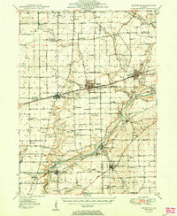
The Fox River corridor serves as the primary artery for settlement and industry in this 1948 survey, where the river-fed towns of Sheridan, Millington, and Millhurst anchor the southern landscape. The diagonal path of the Chicago Burlington and Quincy railroad remains the defining economic engine for the region, connecting the larger hubs of Sandwich and Plano to the broader Illinois rail network. These towns show their mid-century footprints, including the Fair Grounds and local Sewage Disposal infrastructure.
Find a feature on this map
84 named features on this map. Tap any name to fly to it.
Don’t see what you’re looking for? This feature index may not catch every label — zoom into the map to look around manually.
Map Details
Editions of this 1948 Sandwich Map
This is the sole edition of this map. No revisions or reprints were ever made.
Historical Maps of Yorkville Through Time
Featured Locations
- Sandwich, IL
- Yorkville, IL
- Sheridan, Mission Township
- Northville, Northville Township
- Plano, Little Rock Township