1960s Maps of Highland Glen, Elgin Township
Explore 3 historic maps of Highland Glen from the 1960s. These maps offer a rare glimpse into what life looked like during the 1960s — showing old roads, neighborhoods, homes, and landmarks that have changed or disappeared over time.
Whether you're researching your family's past, planning a metal detecting trip, or studying how Highland Glen's landscape evolved across the 1960s, these high-resolution maps are a powerful tool for exploring the history of this region.
- Focus on a specific era: All maps on this page are from the 1960s, giving you a focused view of this time period.
- See what’s changed: Compare century-old streets, trails, and buildings to today's modern landscape using overlays and satellite layers.
- Research with precision: Use these maps for genealogy, historical research, land use analysis, or educational projects.
- View, download, or print: Maps are fully viewable online in high resolution, and can be downloaded or printed for your own records.
Start exploring Highland Glen's history through authentic maps from the 1960s. This is your window into the past.
Highland Glen, Elgin Township maps
(3)- 1962 Map of Elgin, 1964 Print
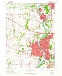 1962 Elgin1964 Print · USGSThe Fox River valley was undergoing rapid expansion in the early sixties as new highways met historic rail lines. Researchers can trace the footprints of institutional landmarks like Elgin State Hospital or locate family plots in Bluff City Cemetery.4 unique versions available
 - 1962 Map of Elgin, 1965 Print
 1962 Elgin1965 Print · USGSThe Fox River valley and the expanding Chicago suburbs are captured here in the early sixties. Genealogists and local historians can trace legacy sites like Washington Church Cemetery, the Elgin Academy, and the State Hospital Cemetery.
 - 1963 Map of Rockford
 1963 Rockford1963 Print · USGSThe mid-century industrial corridor along the Rock River is shown here during a period of rapid post-war growth. Researchers can trace the extensive rail lines of the Chicago and North Western or locate local landmarks like the Rockford Ordnance Depot and Holy Hill.
End of results
Showing maps 1-3 of 3
Frequently asked questions
- What are the different types of historical maps available for Highland Glen?
- What is the oldest map of Highland Glen?
- Where can I purchase historical maps of Highland Glen for my home or office?
- Where can I download high-res historical maps of Highland Glen?
- Are there historical topographic maps available for Highland Glen?
- Is there historical aerial imagery available for Highland Glen?
- Where are historical maps of Highland Glen sourced from?