1970s Maps of Kendall County, Illinois
Explore 3 historic maps of Kendall County from the 1970s. These maps offer a rare glimpse into what life looked like during the 1970s — showing old roads, neighborhoods, homes, and landmarks that have changed or disappeared over time.
Whether you're researching your family's past, planning a metal detecting trip, or studying how Kendall County's landscape evolved across the 1970s, these high-resolution maps are a powerful tool for exploring the history of this region.
- Focus on a specific era: All maps on this page are from the 1970s, giving you a focused view of this time period.
- See what’s changed: Compare century-old streets, trails, and buildings to today's modern landscape using overlays and satellite layers.
- Research with precision: Use these maps for genealogy, historical research, land use analysis, or educational projects.
- View, download, or print: Maps are fully viewable online in high resolution, and can be downloaded or printed for your own records.
Start exploring Kendall County's history through authentic maps from the 1970s. This is your window into the past.
Kendall County, IL maps
(3)- 1970 Map of Stavanger, 1972 Print
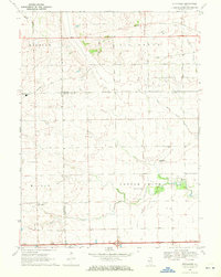 1970 Stavanger1972 Print · USGSThe rural prairie lands of Grundy and LaSalle counties are shown in detail as they appeared in the early seventies. Genealogists can locate family names at Holderman and Hoge Cem or trace the local community near Stavanger and the Nettle Creek Sch.
 - 1971 Map of Newark, 1973 Print
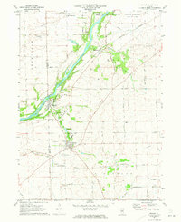 1971 Newark1973 Print · USGSKendall and La Salle counties come together at the start of the 1970s, as the river-and-rail corridor supports a string of small settlements. Genealogists can trace family roots at the Millington Newark Cem or locate the old Bushnell School and the community at Lisbon Center.2 unique versions available
 - 1971 Map of Plano, 1973 Print
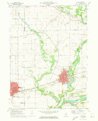 1971 Plano1973 Print · USGSKendall County's river-and-rail corridor is captured here in the early seventies, showing the growth of Plano and Sandwich. Local historians can trace family landmarks and rural infrastructure, from Plano Cem to the Burlington Northern rail line.
End of results
Showing maps 1-3 of 3
Top cities of Kendall County
Frequently asked questions
- What are the different types of historical maps available for Kendall County?
- What is the oldest map of Kendall County?
- Where can I purchase historical maps of Kendall County for my home or office?
- Where can I download high-res historical maps of Kendall County?
- Are there historical topographic maps available for Kendall County?
- Is there historical aerial imagery available for Kendall County?
- Where are historical maps of Kendall County sourced from?