1990s Maps of Kendall County, Illinois
Explore 8 historic maps of Kendall County from the 1990s. These maps offer a rare glimpse into what life looked like during the 1990s — showing old roads, neighborhoods, homes, and landmarks that have changed or disappeared over time.
Whether you're researching your family's past, planning a metal detecting trip, or studying how Kendall County's landscape evolved across the 1990s, these high-resolution maps are a powerful tool for exploring the history of this region.
- Focus on a specific era: All maps on this page are from the 1990s, giving you a focused view of this time period.
- See what’s changed: Compare century-old streets, trails, and buildings to today's modern landscape using overlays and satellite layers.
- Research with precision: Use these maps for genealogy, historical research, land use analysis, or educational projects.
- View, download, or print: Maps are fully viewable online in high resolution, and can be downloaded or printed for your own records.
Start exploring Kendall County's history through authentic maps from the 1990s. This is your window into the past.
Kendall County, IL maps
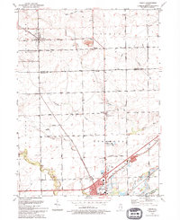
(8)- 1991 Map of Ottawa
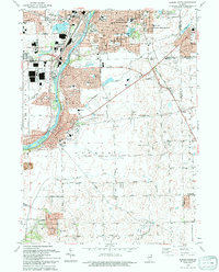
 1991 Ottawa1991 Print · USGSNorth-central Illinois in the early nineties remains a vital corridor of river commerce and heavy rail. Genealogists and historians can trace the legacy of industrial mining near Morris or explore the river-bluff geography of Starved Rock State Park and Buffalo Rock.
 - 1993 Map of Aurora South, 1994 Print
 1993 Aurora South1994 Print · USGSThe Fox River corridor shows significant suburban growth in the early nineties as residential developments expand around Oswego. Genealogists and local historians can trace family sites at Oswego Prairie Cemetery and the small settlement of Wolfs.
 - 1993 Map of Yorkville, 1994 Print
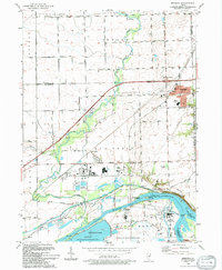
 1993 Yorkville1994 Print · USGSThe Fox River valley in the early nineties shows a landscape of river-front parks and historic transit routes. Genealogists can trace family names at St Patricks Cem and Oak Grove Cem or locate the Glen D Palmer State Game Farm.
 - 1993 Map of Minooka, 1994 Print
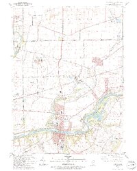
 1993 Minooka1994 Print · USGSMinooka and its river-bound neighbors appear here in the early nineties, showing a landscape defined by massive industrial works and deep prairie roots. Trace the intersection of old and new through the Dresden Station Nuclear Powerplant, the Illinois and Michigan Canal State Trail, and St Marys Cem.
 - 1993 Map of Yorkville SE, 1994 Print
 1993 Yorkville SE1994 Print · USGSKendall and Will counties maintain their rural character in the early nineties, defined by the winding branches of the Aux Sable. Trace local genealogy at the Naausay Cem or follow the historic Indian Reservation Boundary through Seward and Naausay.
 - 1993 Map of Lisbon, 1994 Print
 1993 Lisbon1994 Print · USGSLisbon and Morris appear at the start of the nineties, where the quiet prairie of Kendall and Grundy counties meets the historic canal corridor. Researchers can trace family sites at Saratoga Cem and Saratoga Sch Cem or locate the Nelson Landing Strip and John Moore Park.
 - 1993 Map of Plattville, 1994 Print
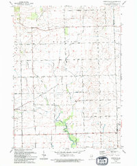
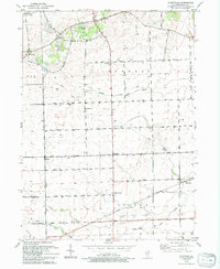 1993 Plattville1994 Print · USGSThe rural prairie of Kendall County is captured here in the early nineties, showing a landscape of established family farms and crossroads communities. Genealogists and local historians can locate Emanuel Cem, Cross Sch, and the historical Chicago Indian Reservation Boundary.
 - 1994 Map of Plano
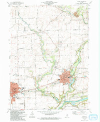 1994 Plano1994 Print · USGSKendall County experienced a mix of industrial rail traffic and suburban expansion in the 1990s as towns like Plano and Sandwich grew. Researchers can trace several family-named burial grounds like Welch Cem and Scott Cem or locate the old Burlington Northern line.
End of results
Showing maps 1-8 of 8
Top cities of Kendall County
Frequently asked questions
- What are the different types of historical maps available for Kendall County?
- What is the oldest map of Kendall County?
- Where can I purchase historical maps of Kendall County for my home or office?
- Where can I download high-res historical maps of Kendall County?
- Are there historical topographic maps available for Kendall County?
- Is there historical aerial imagery available for Kendall County?
- Where are historical maps of Kendall County sourced from?