1970s Maps of Rapatee, Illinois
Explore 1 historic maps of Rapatee from the 1970s. These maps offer a rare glimpse into what life looked like during the 1970s — showing old roads, neighborhoods, homes, and landmarks that have changed or disappeared over time.
Whether you're researching your family's past, planning a metal detecting trip, or studying how Rapatee's landscape evolved across the 1970s, these high-resolution maps are a powerful tool for exploring the history of this region.
- Focus on a specific era: All maps on this page are from the 1970s, giving you a focused view of this time period.
- See what’s changed: Compare century-old streets, trails, and buildings to today's modern landscape using overlays and satellite layers.
- Research with precision: Use these maps for genealogy, historical research, land use analysis, or educational projects.
- View, download, or print: Maps are fully viewable online in high resolution, and can be downloaded or printed for your own records.
Start exploring Rapatee's history through authentic maps from the 1970s. This is your window into the past.
Rapatee, IL maps
(1)- 1974 Map of Fairview, 1978 Print
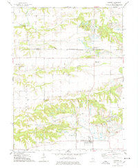 1974 Fairview1978 Print · USGSMid-1970s Fulton and Knox Counties reveal a landscape shaped by both the Chicago and North Western rail line and large-scale coal extraction. Genealogists can locate several family cemeteries, including Markley Cem and Beer Cem, alongside local landmarks like Coal Creek Ch.
End of results
Showing maps 1-1 of 1
Top cities near Rapatee
- Galesburg historical maps
- Canton historical maps
- Knoxville historical maps
- Farmington historical maps
- Elmwood historical maps
- Cuba historical maps
See more
Frequently asked questions
- What are the different types of historical maps available for Rapatee?
- What is the oldest map of Rapatee?
- Where can I purchase historical maps of Rapatee for my home or office?
- Where can I download high-res historical maps of Rapatee?
- Are there historical topographic maps available for Rapatee?
- Is there historical aerial imagery available for Rapatee?
- Where are historical maps of Rapatee sourced from?