1980s Maps of Dana, Illinois
Explore 2 historic maps of Dana from the 1980s. These maps offer a rare glimpse into what life looked like during the 1980s — showing old roads, neighborhoods, homes, and landmarks that have changed or disappeared over time.
Whether you're researching your family's past, planning a metal detecting trip, or studying how Dana's landscape evolved across the 1980s, these high-resolution maps are a powerful tool for exploring the history of this region.
- Focus on a specific era: All maps on this page are from the 1980s, giving you a focused view of this time period.
- See what’s changed: Compare century-old streets, trails, and buildings to today's modern landscape using overlays and satellite layers.
- Research with precision: Use these maps for genealogy, historical research, land use analysis, or educational projects.
- View, download, or print: Maps are fully viewable online in high resolution, and can be downloaded or printed for your own records.
Start exploring Dana's history through authentic maps from the 1980s. This is your window into the past.
Dana, IL maps
(2)- 1983 Map of Dana, 1984 Print
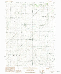 1983 Dana1984 Print · USGSDana and the surrounding Illinois prairie are captured here in the early eighties as the rail-centered economy evolved. Researchers can trace family roots through the St Petri Ch, locate the Bauman Cem, and find the rail junction at Dana.
 - 1985 Map of Fairbury
 1985 Fairbury1985 Print · USGSCentral Illinois in the mid-1980s reveals a landscape shaped by the Illinois Central Gulf rail network and the Vermilion River basin. Trace the roots of local communities from Fairbury to Pontiac, and locate landmarks like the State Correctional Center and High Chapel.2 unique versions available
End of results
Showing maps 1-2 of 2
Top cities near Dana
- Streator historical maps
- El Paso historical maps
- Minonk historical maps
- Chenoa historical maps
- Gridley historical maps
- Evans historical maps
See more
Frequently asked questions
- What are the different types of historical maps available for Dana?
- What is the oldest map of Dana?
- Where can I purchase historical maps of Dana for my home or office?
- Where can I download high-res historical maps of Dana?
- Are there historical topographic maps available for Dana?
- Is there historical aerial imagery available for Dana?
- Where are historical maps of Dana sourced from?