1980s Maps of Kangley, Illinois
Explore 3 historic maps of Kangley from the 1980s. These maps offer a rare glimpse into what life looked like during the 1980s — showing old roads, neighborhoods, homes, and landmarks that have changed or disappeared over time.
Whether you're researching your family's past, planning a metal detecting trip, or studying how Kangley's landscape evolved across the 1980s, these high-resolution maps are a powerful tool for exploring the history of this region.
- Focus on a specific era: All maps on this page are from the 1980s, giving you a focused view of this time period.
- See what’s changed: Compare century-old streets, trails, and buildings to today's modern landscape using overlays and satellite layers.
- Research with precision: Use these maps for genealogy, historical research, land use analysis, or educational projects.
- View, download, or print: Maps are fully viewable online in high resolution, and can be downloaded or printed for your own records.
Start exploring Kangley's history through authentic maps from the 1980s. This is your window into the past.
Kangley, IL maps
(3)- 1983 Map of Streator North, 1984 Print
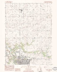 1983 Streator North1984 Print · USGSLa Salle County at the start of the eighties shows a landscape of rail-driven industry and rural townships. Researchers can trace the Atchison Topeka and Sante Fe tracks through STREATOR or locate Grand Rapids Cem and Marilla Park.
 - 1983 Map of Leonore, 1984 Print
 1983 Leonore1984 Print · USGSLaSalle County farmland meets the winding bluffs of the Vermilion River in this early 1980s survey. Researchers can trace the rural layout of Leonore and find legacy landmarks like Lost Land Cem and Eagle Sch.
 - 1985 Map of Ottawa
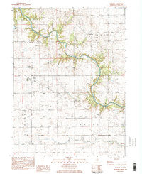
 1985 Ottawa1985 Print · USGSThe Illinois River valley in the mid-1980s shows a landscape balancing river commerce with sprawling energy and mining operations. Researchers can trace the layout of mining towns like Coal City or find family landmarks such as Oakwood Memorial Cem and Smiths Mound.
End of results
Showing maps 1-3 of 3
Top cities near Kangley
- Streator historical maps
- Pontiac historical maps
- La Salle historical maps
- LaSalle historical maps
- Marseilles historical maps
- Oglesby historical maps
See more
Frequently asked questions
- What are the different types of historical maps available for Kangley?
- What is the oldest map of Kangley?
- Where can I purchase historical maps of Kangley for my home or office?
- Where can I download high-res historical maps of Kangley?
- Are there historical topographic maps available for Kangley?
- Is there historical aerial imagery available for Kangley?
- Where are historical maps of Kangley sourced from?