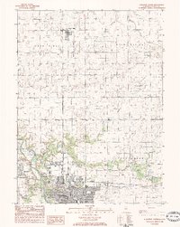
1983 Map of Streator North
USGS Topo · Published 1984About this map
Streator serves as the industrial and social hub of this region in the early 1980s, where the Vermilion River and a complex network of rail lines converge. The landscape is defined by the heavy rail infrastructure of the Atchison Topeka and Sante Fe and the Old Burlington Northern Railroad, facilitating the movement of goods through the Farm Ridge and Grand Rapids areas. Beyond the urban core, small settlements like Grand Ridge and Richards are surrounded by extensive agricultural lands. Local history and genealogy are well-represented by several burial grounds, including St Anthonys Cem, Emery Green Cem, and Mackey Cem. Recreational and community landmarks such as Marilla Park, the Ymca, and the Streator Country Club reflect the established social fabric of this La Salle County community during this period of the late twentieth century.
Find a feature on this map
39 named features on this map. Tap any name to fly to it.
Don’t see what you’re looking for? This feature index may not catch every label — zoom into the map to look around manually.
Map Details
Editions of this 1983 Streator North Map
This is the sole edition of this map. No revisions or reprints were ever made.
Other maps of this area

1892 · Marseilles
USGS Topo · 1:62,500

1892 · Ottawa
USGS Topo · 1:62,500

1915 · Ottawa
USGS Topo · 1:62,500

1916 · Marseilles
USGS Topo · 1:62,500

1925 · Streator
USGS Topo · 1:62,500

1927 · Streator
USGS Topo · 1:62,500

1940 · Marseilles
USGS Topo · 1:62,500

1946 · Ottawa
USGS Topo · 1:62,500

1958 · Odell
USGS Topo · 1:62,500

1958 · Aurora
USGS Topo · 1:250,000