1960s Maps of Peru, Illinois
Explore 4 historic maps of Peru from the 1960s. These maps offer a rare glimpse into what life looked like during the 1960s — showing old roads, neighborhoods, homes, and landmarks that have changed or disappeared over time.
Whether you're researching your family's past, planning a metal detecting trip, or studying how Peru's landscape evolved across the 1960s, these high-resolution maps are a powerful tool for exploring the history of this region.
- Focus on a specific era: All maps on this page are from the 1960s, giving you a focused view of this time period.
- See what’s changed: Compare century-old streets, trails, and buildings to today's modern landscape using overlays and satellite layers.
- Research with precision: Use these maps for genealogy, historical research, land use analysis, or educational projects.
- View, download, or print: Maps are fully viewable online in high resolution, and can be downloaded or printed for your own records.
Start exploring Peru's history through authentic maps from the 1960s. This is your window into the past.
Peru, IL maps
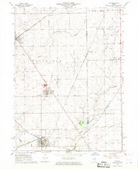
(4)- 1961 Map of Aurora
 1961 Aurora1961 Print · USGSNorthern Illinois at the height of the post-war era reveals a landscape of massive industrial works and thriving river towns. Genealogists and historians can trace the paths of the Lincoln Highway or locate long-standing landmarks like the Green River Ordnance Plant and Starved Rock State Park.
 - 1966 Map of Ladd, 1968 Print
 1966 Ladd1968 Print · USGSIn the mid-1960s, these Illinois prairie townships remained deeply marked by their coal mining and railroading roots. Researchers can trace the industrial footprint at Ladd, locate family plots at Miners Memorial Cem, or follow the path of the historic Plank Road.2 unique versions available
 - 1966 Map of La Salle, 1968 Print
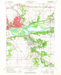 1966 La Salle1968 Print · USGSThe industrial corridor of the Illinois and Vermilion Rivers thrived during the 1960s, anchored by the hubs of La Salle and Peru. Genealogists and historians can locate landmarks like St Vincent Cemetery, St Marys Hospital, and the rail networks serving Oglesby and Cedar Point.3 unique versions available
 - 1966 Map of Spring Valley, 1968 Print
 1966 Spring Valley1968 Print · USGSThe Illinois River valley in the mid-sixties is a dense corridor of rail-and-river industry and established parish life. Genealogists and historians can trace the footprint of Spring Valley and Granville through local sites like Sacred Heart Cem and Hopkins High Sch.2 unique versions available
End of results
Showing maps 1-4 of 4
Top cities near Peru
- La Salle historical maps
- LaSalle historical maps
- Mendota historical maps
- Spring Valley historical maps
- Oglesby historical maps
- Henry historical maps
See more
Frequently asked questions
- What are the different types of historical maps available for Peru?
- What is the oldest map of Peru?
- Where can I purchase historical maps of Peru for my home or office?
- Where can I download high-res historical maps of Peru?
- Are there historical topographic maps available for Peru?
- Is there historical aerial imagery available for Peru?
- Where are historical maps of Peru sourced from?